Sunday, 26 September 2010

Thursday 23rd: A Walk in the Alps

Some campers on the site recommended this walk: an easy path with incredible views. We needed to start from a point 2,200 metres up that meant first a train, and then the cable car seen here in the photo. All included in our rover ticket, thankfully, as just this cable car, one-way, would have cost us £15 each.

It’s cooler at the top, but not cold, and we set off in bright sunshine on a well-surfaced path. The photo shows Jane rarin’ to go set against the backdrop of a huge vista.

It’s like walking at the top of the world, and we start looking for a handy rock to sit on to eat our sandwiches and enjoy the view. It must be that all other walkers have the same thoughts at this precise point because we come across the following notice written, as are all the best notices abroad, in quaint English.

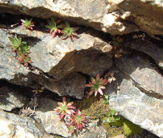
Lunch being finished, and the debris suitably deposed in our dust-pan, we continued on the path that gradually rounded a headland of rock to lead into a south-facing valley. Here there were many more alpine plants in the rock crevices, and mixtures of heather and an unidentified red-leafed shrub covering most of the open ground, looking like a Scottish glen. The next two pictures are examples.

There’s been something of a problem taking the big mountain views on this holiday. The Eiger, Mönch and Jungfrau peaks dominate the scenery. You take them from all angles, distances and weather and light combinations. Yes, they are fantastic, but soon you realise that you’ve got far too many snaps of them, and none of them is as good as the professional photos in books, brochures and on the net. People are fed up with seeing them, anyway. After all that, would you believe it, I’ve included one last one of the north face of the Eiger! It just looks as if I’m about to climb it, alpenstock in hand, and be back in time for tea. We caught the mountain train down shortly after.

Saturday, 25 September 2010

Tuesday: The Top Station

I imagine almost everyone who visits this area takes this trip, to the highest station in Europe. It was conceived by a Swiss industrialist on an Alpine hike in 1893, and was completed in 1912. His idea was to extend the existing railway from Kleine Scheidegg, at 2,000 metres, to the top of the Jungfrau, at 4,158 metres, by tunnelling into the Eiger and diagonally upwards and across to reach the Jungfrau summit. It turned out to be a project beset by geological and financial problems, so they stopped short of the target, having reached 3,454 metres. Still pretty remarkable! This poor reproduction will perhaps give you some idea of the tunnel’s route.It's the dotted red line.

The train stops in the tunnel twice on the ascent so that passengers can walk through galleries to observation windows set in the side of the mountain. These galleries have access doors onto the mountain itself from which climbers have been rescued. This is the view from the Eigerwand stop (see fuzzy plan above) There’s not much of the Eiger in view other than a strip of rock on the right because it’s a vertical cliff.

So here we are at the top, with Jane in front of the longest glacier in Europe being supported by a pole shoved up the back of her jacket. It was very slippery and cold, but the scenery was superb. It’s possible to see France, Germany and Italy in clear weather- which we had- so we’re claiming all three.

How do they survive in this temperature? A colony of alpine choughs lives at the top, cleverly scrounging tit-bits from the tourists. We unfortunately had eaten our sandwiches by this time, so one of them crapped on Jane’s hat: just remember to save some next time.

They can’t resist a bit of Disney: an Ice Palace, full of chambers and ice carvings. This is a pair of eagles, the best of the bunch, the others being, predictably, polar bears and penguins, some of which appeared to have been done over by vandals with a blowlamp.

In summary, it was a brilliant day out with the incredible views as the crowning glory.

Tuesday, 21 September 2010

Saturday 19th: Boat Trip

Before coming to Switzerland we had bought a bargain rover ticket covering bus, train and boat, so even though the clouds were low and the light gloomy we decided to go for it- a boat trip, that is. Interlaken is between two lakes (hence the name Interlaken, I guess), so we took the boat plying the bigger lake to the town of Thun at the far end, about 15 miles from Interlaken. Thun’s history goes back to pre-Roman times and following the Roman occupation in 58BC was an important administrative centre. The castle dates from 1190, and is shown in the photo with other ancient and picturesque buildings.

The boat zigzags across the lake, calling in at most towns and villages on the banks. It’s obviously prime dwelling location and few detached houses anywhere in the area seem to be up for sale for less than £1,000,000, so it’s certain that none of the lakeside houses here would go for less than £2 million

The lake itself is very pretty with small, partly wooded mountains sloping steeply down to the shore, with the high peaks in the background (when you can see them!). Also, the odd waterfall, or what we assumed to be a waterfall rather than the combined effluent stream from the houses on the cliff.

The shipping services started on lake Thun in 1835 with the SS Bellevue operated by an enterprising hotelier. This is the boat in question: a more interesting picture than one of the modern, much larger boat we travelled in.

Sunday, 19 September 2010

Wednesday 16th: Schynige Platte

This was a journey by rack and pinion railway, starting from just outside Interlaken, to a plateau 6,500 feet up. The little train is shown in the distance chugging away amidst lovely scenery, looking down towards Interlaken. Our campsite is on the far side of the town not far from the lake.

The plateau is pretty bleak, but is the starting point for many mountain trails. There are farm buildings even at this elevation, and we opened a gate for an old farmer patrolling in his ancient truck. He stopped the truck and shook hands with us, then rumbled off in the truck singing and yodelling at the top of his voice! First hand experience that they really do yodel.


There is also a huge alpine garden laid out on a rocky prominence, but as we’re nearing autumn there wasn’t much life in it. The few plants that were performing were bright and fresh in colour, and an indication of what the garden must be like in spring.

The big views from up here are of the high peaks, and in particular the north face of the Eiger. This is the forbidding photo below: the face is 5,900 feet sheer. Just before we came away we watched a TV programme about the severe challenges the climb presents and how 64 climbers have died since the first ascent in 1938. Chris Bonnington featured prominently, and recounted stories of the extreme difficulties climbers face. It usually involves at least one night on the mountain - there’s even a ledge named “death bivouac”. Bonnington himself climbed it in 1962.
However, right at the end of the programme, we saw speed climber Ueli Steck who scaled the face in 2hrs 47 minutes in 2008! However even-handed traditional climbers like Bonninton are, they must be pig sick that their death-defying exploits lasting for days on the mountain are almost rubbished by some fitness nut tearing up the face in 2¾ hours!

Friday, 17 September 2010

Tuesday 14th: Trip to Murren

The first leg of the journey is by train to Lauterbrunnen, just outside which is located the Steubbach Falls, Switzerland’s tallest, 300 metres high. It was first measured in the 18th century by dangling a rope from the top and adding lengths until it reached the bottom. It is impressive, and especially so in springtime from the volume of melting snow. The picture shows the waterfall apparently showering onto a house roof, but it’s actually well behind the town.

The ingenious Swiss have created a tunnel and walkway behind the waterfall’s base, so you can look through it to the beautiful Lauterbrunnen valley. Unfortunately, the water has fallen such a long way that it has atomised and just creates a mist that prevents you from clearly seeing the valley. The mist also blows back through the observation holes and soaks you, or to be more precise in the photo below, soaks Jane. Now was all that engineering effort worth it?

So on from Lauterbrunnen, up on the cable car to connect with the cliff-edge railway that runs to Murren. Wonderful views of the valley and mountains from the cable car and railway.

Murren itself is a walking resort in summer and a skiing haven in winter, discovered by the English as long ago as 1840. “No motor vehicles”, the guidebook said, but on arrival we were nearly bowled over by a Land Rover. Were we really expecting only milk floats in the 21st century? It was in fact a real town, as opposed to a purely tourist creation, with a number of old wooden buildings, although the example below has been dressed up a bit.

What Murren has got is unparalleled views. It’s on this clifftop 5,300 feet up, with vistas into the valley below and the snow-clad Alps above. You can’t reproduce this panorama with a camera (well, I can’t!), but this is the best I can do, looking towards the Eiger. Question of the day – is that the Swiss national flag in the photo, or the flag on the 18th green? Bear in mind that any balls landing in the rough would need to be chipped back from the valley 2,500 feet below.

Thursday, 16 September 2010

Switzerland September 2010

Friday 11th: Arrival at Interlaken

We left Alconbury last Thursday, and nearly made Switzerland in one day! Not by design I should add, but we just couldn’t find a motorway services in France to park up for the night: they were totally full with lorries. We often do an overnight stop in services when we plan to cover a big mileage on the first day because you just pull into the next services when you’ve had enough, with no campsite to find or time constraints.

But why the problem this time? Then the penny drops: we’re near the German border, and what’s changed in the last few years is the mass of extra lorries coming from the new EU countries like the Baltic States, the Czech Republic and particularly Poland. We head down towards the Swiss border where these lorries don’t go- and suddenly there’s plenty of room. We eat dinner at 10.30pm, but who cares, and after nibble on a few savoury sticks (Paluski Polish sticks, 99p from Tesco- so it’s no good us complaining about all these extra lorries!)


So now we’ve arrived at Interlaken. The site has the unlikely name of “The Lazy Rancho”, shades of Texas rather than Switzerland, but very friendly & helpful proprietors who speak fluent English.


From our pitch we have a 5* view of the Eiger, Mönch and part of the Jungfrau. It’s interesting how their appearance changes depending on the time of day and weather. The following two photos give some idea of this. The first is taken at sundown and the second in near darkness, both with some cloud.