Sunday, 14 July 2024

Arras: Carriere Wellington

 The tour group, about a dozen of us, is first briefed on safety and then issued with a First World War soldier’s helmet for protection. 

The guide explains, in English and French, that the tunnels started as separate limestone quarries from the Middle Ages onwards. By the outbreak of war in 1914 they covered a vast area in 25 separate locations.  

Early on the war had reached stalemate, with allied trenches facing the Germans’ a few hundred yards apart. Each side looked for a breakthrough, and one method both used was to tunnel to lay charges under the opposition lines hoping to weaken the line enough to storm it with an assault over no-man’s land. This rarely worked, and thousands lost their lives to machine gun fire. 

By September 1916 the British had discovered the existence of the quarries under Arras, some of which extended under the German lines. The idea was to join them up and mount a surprise attach behind enemy lines, our troops emerging from the old quarry workings to seize and hold enemy-occupied territory. 

But could they be joined up? The New Zealand Tunnelling Company was tasked with the work, to be completed by April 1917 to support a general attack that was being planned. The New Zealanders completed the work on time, digging an amazing 6 miles of tunnel. The complex was named Carriere Wellington (Wellington Quarry), after Wellington, the capital city of New Zealand, as recognition of their herculean achievement. 

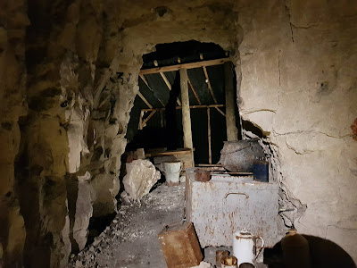
We’ll follow the tour now and see how the joined up tunnel system was used as we proceed. This photo shows the group just into the tunnels, duly helmeted. The guide has stopped, back to the wall, to point out relevant features. Here, the roof is higher due to old quarrying.

She indicates ventilation shafts, and some rusty worktools that were found.

The Tommies sat behind the tools are projected on the wall to remind us what the tunnels were created for – the surprise attack. 

There are recreated bunk beds, cooking and toilet facilities, examples of which are shown below. Thankfully, they have not attempted to recreate the smell of the 24,000 troops living down here if only for a short time before the attack.


At dawn on 9th April 1917, the 24,000 troops sallied forth and the battle began. Unfortunately, the planned supporting attacks on other parts of the line were delayed and the action fizzled out, with punitive loss of life on both sides. Arras carried on as a front line bastion until the end of the war when Grandpa Sanders returned to Wales and used his saddlery skills to set up a shoe repair shop. 

It’s impossible to appreciate the trauma soldiers experience in war, and the First World War would have been one of the worst for creating nightmare scenarios that only other Tommies who fought could appreciate. But visiting the tunnels and other scenes of combat allow us to reflect on what they went through and the sacrifices they made to enable us to enjoy the comfortable lifestyle we have today.


Arras: 30th May

This is our last stop before crossing to Folkestone: from here it’s an easy 80 mile motorway run to Calais. However, the weather has deteriorated and we have rain showers and a 16C max temperature, but we are determined to visit Arras to see where Grandpa Sanders was stationed in World War 1. He was a saddler, working just behind the front lines. 

Arras was on that front line for most of the 1914-18 war, occupied by the allies but under constant German shell fire. The first photo below, taken before 1914, shows town hall and belfry ( Belfroi de l’Hotel de Ville) in the Place des Heros, one of the two main squares in the city. 

Intense shelling by the Germans quickly reduced 90% of Arras to rubble. This is the same square later in the war.

At the end of the war in 1918, with such complete destruction, it would have been easiest to build a brand new town. However, it was decided to faithfully recreate all of the previous buildings using original plans. So, the town hall sprung to life again, magnificent even on this dull day.

The whole central area has been faithfully reconstructed in the Flemish style, some 230 building like these below, so the info board tells us.

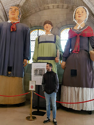
The town hall building is open to visitors, so we enter to be faced by three giant figures. The tradition of these giants is widespread in northern France and Belgium, and dates back to the 16th century. They are meant to represent valiant protectors from the town’s history, clearly not very effective in that role as they were destroyed in WW1 along with the rest of the town. Undaunted, the townsfolk revived the figures in the 1920s, but these fared no better in protecting the town as they were also obliterated by the Germans in WW2. We move on to the 1980s for the latest version of the giants, seen here in the photo. Perhaps they’ll do better against the Russians or Chinese.

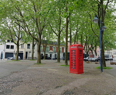
Moving just out of the centre, in a rather ordinary square, we spot an out-of-place object.

The clue is in the square’s name: Place d’Ipswich. Arras is twinned with Ipswich. The whole square contains nothing noteworthy except the church, which is pleasant with a fine stained glass window - modern, but then we’d not expect glass to survive either world war.


We move on and pass an ornate concert hall that to me looks like a fire station – in my mind’s eye,  the white doors will suddenly burst open and two keystone-cops type fire engines will thunder forth, brass bells clanging and firemen holding on for dear life.

Now we’re at Arras’s cathedral, a late 18th century build, or rather rebuild following WW1. Then and now photos tell the tale.


We haven’t really done justice to Arras due to poor weather and lack of time, but we did make one other trip to Arras that was weather-independent, a guided trip around tunnels known as the Carriere Wellington.


Pont du Gard

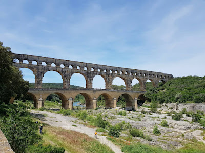
 Our last trip out before leaving St Remy was to the Pont du Gard. This is a Roman aqueduct built in AD 60 to carry water 30 miles from source near Uzes to the city of Nemausus, present-day Nimes. To do so it was necessary to cross the river Gardon with this spectacular aqueduct.

To get an idea of scale, the next photo is taken from the road bridge that runs alongside the lower tier. The road bridge was added in the 17th century but is not now used for vehicles apart from those of the tourist office that operates the site.

The tourist centre runs cafés, souvenir shops and exhibition hall in a complex near the large car park (9  euros). When we visited 35 years ago there was nothing here and you parked where you could for free. It was so quiet that we sat by the river for a long time and watched two kingfishers fishing in the river. Now both the aqueduct and the river are popular destinations for tourists, school parties, bus trips and canoeists. The view from the road bridge shows the picturesque river, with canoes.

Walking to the aqueduct we passed some attractive provencal buildings that seem to blend in with the landscape, for example.

And a final look at this awe-inspiring structure, 160 feet high, 900 feet long, estimated weight 50.400 tons, and taking around 15 years to complete. It was constructed largely without using mortar, with some of the blocks weighing 6 tons.