Wednesday, 16 May 2012

Krka National Park

This is our main reason for being here, and Camp Marina is right next door. In fact, Mr Marina and Son of Marina run mini-bus tours into the park. We take a tour with them, and it is excellent. We also go back, ourselves, several days later and explore in more detail. The blog description combines both visits.
Krka Park covers the lower reaches of the Krka river valley. The river is set in wooded hills and falls through several series of waterfalls within the Park. It is incredibly picturesque.
Let’s look at some of the scenery. The waterfalls were created by the erosion and depositing of limestone and so flow in multiple levels rather than one big drop. The next three photos are examples.


Going upstream 10 miles or so is an island monastery, again in an idyllic setting. It’s currently occupied by only 6 monks.


The Krka Serbian Orthodox Monastery is perhaps the more interesting and is a fully working teaching establishment. These are its serene cloisters.


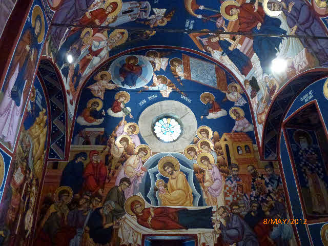
It was badly damaged during the homeland war. As in other parts of the country, this damage was repaired so well as to be mostly undetectable. The only parts that give the game away are the wall paintings, which were renewed. Their colours are too fresh to be more than a few years old.


The Park supports a tremendous variety of wildlife. This is not surprising with such an abundant water supply for trees, plants and animals. The water is also very clear and supports a large fish population. The next photo is looking down into one of the pools, but could have been taken in an aquarium.


The park is serviced by a network of wooden walkways that thread through the watercourses and through the trees and undergrowth. We didn’t see any of the wolves or wildcats claimed to be around somewhere- but how about an iridescent dragon fly


At a practical level, the Krka River was an important former source of power. There were mills of every description, and cloth fulling. In fulling, the water was used first to wash the cloth and then hammers, powered by water wheels, pounded the cloth until the fibres matted into felt. The next photo shows the washing area. It could be the witches’ cave in Macbeth.
Interestingly, after the cloth fulling business ceased, the locals used to come to wash their own clothes here, and then dry them using the fullers water-powered hammers. Presumably they removed their garments much sooner than the fullers would have done, to prevent them being turned into felt.


Here's a photo of those hammers located in the chamber next door to the washing. Mind your fingers when putting your clothes in!


Now, what have we got here? Looks like a set of giant dumb-bells. It’s actually a turbine from the hydroelectric plant that was installed here, and is about 2 metres tall. Not knowing much about Croatia, we vaguely think that they’ve done well to catch up with our technology. Not so: the hydroelectric generating station at Krka was commissioned in August 1895, only 2 days after the Niagara Falls plant that was the world’s first. Both Krka and Niagara generators were based on a powerplant design by Nikola Tesla, a Croatian born less than 100 miles from the Krka site.


Krka was a truly captivating place.


Up the Coast to Šibenik

The whole coastline is scenic bays and inlets, and the main road following these twists and turns was surprisingly good, and not too slow. 30 miles north of Dubrovnik we had to cross the 6 mile stretch of Bosnia and Herzegovina that reaches right down to the sea, thereby cutting Croatia in two. So more border formalities but nothing too long-winded. Bosnia and Herzegovina (what a mouthful- why didn’t they call themselves B&H, like B&Q!) was allocated this strip in communist times to prevent their state from becoming land-locked. They built the port of Neum to handle the exports that were expected but never came, and today practically all exports leave by road from the other end of the country.
We left Camping Kate to arrive by mid-afternoon at Camping Marina. Ladies must have influence in Croatia. Marina herself ran out to shake hands and welcome us to her camping. Her husband, who can only be thought of as Mr Marina, came and lopped off some tree branches so the caravan would fit into our chosen pitch. The site had got a nice laid-back feel, which perhaps means slightly untidy; for example, Mr Marina slung the lopped-off branches on the back of the pitch. However, the facilities were spotless.
Just one photo now, of the site entrance, with a rally car doing a nearly-handbrake-turn. This was the day following our arrival when a rally was held on the road outside.

Sunday, 13 May 2012

The Homeland War

Yugoslavia as a country dates from 1918, an amalgamation of small states of different religions and ethnic origins. In 1946 a major change occurred with the creation of a communist regime under President Tito when the original states became republics under a central communist control, as in the USSR itself.
Following Tito’s death in 1980 ethnic loyalties became more focused, and tensions were further heightened from 1987 when Milošević, President of the Serbian Party, started a propaganda campaign promoting Serbian mistrust of other ethnic groups. The Serbs were the largest ethnic group in Yugoslavia, and Milošević wanted Serbian fears translated into total support for his attempts to restore hard-line communism under Serbian central control.
Croatia and Slovenia, regions with different ethnic majorities, naturally found this policy unacceptable. They had anyway moved towards more democratic government. So, in June 1991, these two states declared full independence. Slovenia was better prepared, and their militia ejected the Yugoslav army units stationed within their borders. Croatia didn’t have a military force, so set about creating one and obtaining weapons from the Yugoslav Army bases in Croatia. Amazingly, they were quite successful in this.
I couldn’t establish whether this army base-cum-holiday complex near Dubrovnik had been attacked or not, but it certainly looked like it. The next three photos show a state of decay far greater than would be expected than from simple abandonment.


They also had the skills to make some military hardware, for example this gunboat on display in Dubrovnik port under the inscription “ The First Battleship of the Croatian Navy”


Bitter fighting occurred between Croats and Serbs living both within and outside Croatian borders, and with the Yugoslav army, which also encouraged and armed Serbian aggression. The conflict lasted from 1991 until 1995 and is known here in Croatia as the Homeland War. Finally, through the efforts of the international community and UN forces, a negotiated settlement was reached in 1995.
Croatia now looks forward and has done a brilliant job of repairing the physical damage to the main towns, although there is plenty of evidence left in ruined buildings inland. However, every opportunity is taken to remind residents and visitors of the aggression perpetrated by Croatia’s neighbours. But Croatia does not come out with a clean slate; all sides have been called to answer charges of ethnic cleansing, another name for genocide.

Thursday, 10 May 2012

May 2nd: Trsteno Gardens

In 1502 a Dubrovnic nobleman built his summer villa here at Trsteno, with extensive formal gardens laid out according to the fashion of that era. The villa and gardens were maintained by the same family until 1948 when the newly installed communist regime confiscated the estate as part of their removal of the aristocracy. Today it is still run by the state, the Croatian Academy of Science, which has further developed the grounds to include an arboretum.
The setting is stunningly beautiful, high up and directly overlooking a coast of little bays and a sea dotted with islands. The first photo is a typical example.
Being an arboretum, it was full of obscure trees, and they don’t come stranger than this one. Remember a sci-fi book called “Day of the Triffids”? The trunk on the right just above the hedge line looks like it might be waving to us. And are those two discs its eyes?
Odd trees, now big trees. It’s 150 years old and has grown to well over 100 feet tall. The discs on the trunk are identification data (I bet you guessed they weren't really eyes), but we didn’t remember to note down the details. It’s not clear who is propping who up between Jane and the tree.
We ate our sarnies in this shelter overlooking the sea. The islands seemed to go on forever into the distance, getting hazier and hazier. A perfect spot, we all agreed.
After lunch we descended the steps at the side of the shelter into a terraced, overgrown garden. A real suntrap, and just the sort of place that would attract snakes. Not that we considered such a possibility- until I nearly stepped on one: a large brown snake basking at the edge of the path. It rapidly shot off into the undergrowth, and has defied our efforts since to ID it. We have internet access so were able to discover that there are 16 species of snake in Croatia, some with sub-species, in the case of the grass snake, 8 sub-species. Paul is quick off the mark with his camera, and got the tail before the creature disappeared. So, what do you think it was? Post answers on the blog. Winner gets a Monty Python or Black Adder DVD.

Walking on a little more carefully through the rest of the garden, we came to the mill, a rather dilapidated structure full of old equipment to do with milling, and pressing grapes and olives. It was covered in dust, bits of wood and rubble, looking more like a medieval torture chamber that had laid undiscovered in some castle dungeon for centuries.
The formal features of other great estate gardens were there too: the herb garden, roses and box hedges, a fountain with classical statues, and so on. The water feature shows a glum looking Neptune with trident, presiding over a goldfish pool, flanked by female aides. It’s getting him down that in all these years he’s not managed to spear a single goldfish.
The gardens were well worth searching out. There was no sign from the main road and then no indication where the entrance was on the tiny perimeter road we found after passing through a campsite. Trsteno Gardens website is all about praising its own horticultural achievements, so perhaps the management doesn’t see direction signs as part of the job, which is ironic because the tree descriptions (the discs in the photos) were clear and comprehensive!


Sunday, 6 May 2012

April 30th: South of the Border

BLOG NOTE: All the photos on older blogs are now visible.
Today we were on an organised bus trip to Montenegro. The border is 25 miles south of the campsite, and the bus picked us up on the main road by the site gates on its way from Dubrovnik. We drove through a lush agricultural area leading up to the border crossing. Although Croatia has warm, dry summers, it’s evident that there is plentiful rain in the winter months.
We waited in the queue of vehicles for about 90 minutes whilst the customs and border officials checked passports. The courier said they were sometimes pedantically officious, as they were being today. There is not much goodwill between Croatia and its southern neighbours (Montenegro and Bosnia & Herzegovina) who they fought in the war that split up the former Yugoslavia. Each country of course claims to have been the innocent victim. But more of that in another blog.
Eventually leaving the borders behind, we were soon driving around the gulf of Kotor. This is described as the most southerly fjord in Europe, and is certainly impressive with high, steep mountains lining the long, narrow sea inlet. The photo shows our Lady of the Rock Island in the gulf. It’s an artificial island made after fishermen found an icon of the Virgin on rocks nearby, as you do. To celebrate this miraculous event, shiploads of stones were tipped on the seabed and a church built on top to house the icon. I suppose the real miracle is that the island itself has survived, what with earthquakes and the wash from cruise liners!

The walled town of Kotor is at the end of the gulf. It’s a UNESCO World Heritage Site and could have been built by Disney. Because the gulf is a deep, sea inlet, Kotor has been an important port and naval base for all of its history.
This is one of the squares, featuring St Tryphon’s cathedral. Never heard of St Tryphon? Well, back in 890 a passing ship loaded with relics happened to have the head of St Tryphon on board and for sale. This was snapped up by the townspeople and adopted as their patron saint. Such relics were valuable assets for the local economy in attracting pilgrims.

Kotor is full of narrow streets and alleys; perhaps the most impressive bits are the fortifications that run round the town and then right up the mountain at the back, Great Wall of China style. A lookout was permanently stationed on the top tower to warn of the approach of raiders.

All towns and cities right along this side of the Adriatic were dominated by a variety of rulers; some were independent for a time. It was all to do with protecting trade routes.
Kotor was no exception and fell under the influence of the Serbs, Austria-Hungary, Bosnia, then independent, Turkey, Venice (nearly 400 years), Russia, Habsburg Empire, Yugoslavia, and now Montenegro. The campsite proprietor said Kotor should really belong to Croatia. I don’t think the Kotorians care as long as the tourists keep coming in place of those pilgrims of yesteryear.
The next stop was Budva, another old walled town, this time in a seaside and more touristy environment. It’s all atmospheric narrow streets and little squares. The photo shows a pretty corner of the battlements momentarily clear of trippers.

Now who are these two belles in front of the big bell?

Every watersport imaginable is on offer from the harbour area, so we were not surprised to see a paraglider towed by a powerboat running along the shoreline towards the Old Town. Whilst you can clearly see the two passengers, it’s not possible to be sure whether there are looks of terror on their faces.

A few miles the other side of Budva is delightful St Stefan’s island. The buildings date back to the 15th and 16th centuries, but the island was abandoned between the two World Wars and became derelict. It was restored in the 50’s as a resort for top communist officials, each house being made into a self-contained luxury suite. Now it’s an exclusive hotel where a suite will cost you up to 3,000 euros per night + 10% service charge. The photo of the island is taken from the Aman Hotel online brochure.

After St Stefan’s, we head for home. The border crossing takes all of 5 minutes: the officials have perhaps mellowed with thoughts of dinner and a bottle of wine. So we arrive back, unexpectedly in daylight, passing fine views of the coast as we drive towards the setting sun.

Wednesday, 2 May 2012

Out and About Near the Campsite

The campsite is in the middle of a large bay with Dubrovnik just beyond one end and the small resort of Cavtat at the other. Cavtat is the oldest settlement on this part of the coast having been settled by the Greeks in the 3rd century BC. There are no Greek remains as the town was ransacked a millennium later. It was a resort catering exclusively for the wealthy until tourism got going in the 1980s and still retains a classy feel as well as being highly photogenic. So, for the moment, it’s avoided a further ransacking by lager louts.
On the way back from Cavtat we stopped for a walk. The path wound down from the pull-off to the sea, passing small trees and scrub offering shelter to all sorts of creatures.
It’s difficult to spot birds flitting through this sort of dense undergrowth never mind identifying them, but this hoopoe obligingly sat on the path for us. Hoopoes are crested birds that, when in flight, look like giant butterflies.
Arriving at the end of the path at the seashore, we noticed a kind of shed housing these two enormous wine barrels. This area is an important wine producer and these barrels were evidently for bulk storage of wine. Although not containing any wine, the barrels were in good repair and seemed to have been in recent use.  However, there were no vineyards or wine presses anywhere around, or even any houses, so why the barrels were located here at the end of a dead-end road is a mystery.
Another nice view to finish with, over the scrub towards the offshore islands. Most of these islands have some dwellings and are serviced by car ferry from Dubrovnik harbour where we originally docked. The larger islands farther up the coast have substantial populations and a thriving tourist trade. Croatia has more than 1,000 islands, so there’s plenty of choice!

Sunday, 29 April 2012

Dubrovnik Old Town

Dubrovnik’s city walls are intact, dating mainly from the 12th and 13th centuries although extended and repaired many times subsequently. A great way of checking out the old city itself is to walk the full circuit of these battlements. There are some panoramic views of the re-roofed buildings in the town especially from the top of the fortress dominating the northern side looking in the direction of the sea.
Back down at street level, the town is laid out in a grid pattern resulting from the substantial rebuild following the earthquake of 1667 when 5,000 inhabitants perished. Dubrovnik also received a severe battering when it was shelled by Serbian forces during the Homeland War as it is known here, from November 1991 to May 1992. The destruction of that time has been so well repaired you would not realise that there had been any damage. The photo below shows the main street that contains the expected typical tourist shops, but quite reasonable quality and prices (i.e. we’ve seen a lot worse!)
There are some interesting historic buildings that predate the earthquake, for example the Sponza Palace and the municipal bell tower in the next photo. The Sponza Palace was once the city’s customhouse and mint, with an inscription inside designed to deter merchants from cheating on weight: “When I weigh goods God weighs me”
The bell tower contains some detailed figures that strike the bell on the hour and, so my guidebook tells me, are known as the “Greenies” on account of their weathered copper colour. They are however copies of the 15th century originals.
On either side of the main thoroughfare, the parallel streets run on higher and higher levels, especially heading for the North Gate, the exit needed to catch the bus back to the campsite. Take a look at the one we plodded up. It looks pretty at the start and pretty exhausting at the top.
The overall strong defensive position of the town is best shown in this last photo, taken from the road leading out of Dubrovnik. Unfortunately, it’s looking towards the sun but the circuit of the massive walls can be clearly seen and the characteristic red roofs. Invaders these days are confined to tourists and cruise ships, which are welcomed rather than repelled.

.