Between Munich and the Alps are a number of
lakes of all sizes. Our campsite is on one of the smaller ones, about 3 km by 1
km. It’s a lovely location (I’m running out of different words of praise to use)
as the photo shows, with Jane swimming in the lake.
The local town is Murnau, quite up-market and beautifully
maintained. It was extensively rebuilt following a fire in 1835, although is first
documented in 1150. Some of the buildings have external painted decorations that
are a feature of Bavaria. This is the town, with the Alps in the background.
Jane’s sister Ruth lives at Feldafing on one of
the largest lakes in the region, Lake Starnberg. The lake is very popular for
all types of water activities (perhaps not white water rafting) and on clear
days the Alps are visible, as in the photo. The boat is an ancient ferry
serving Rose Island a few hundred metres off shore.
The town of Starnberg was celebrating its 100th
anniversary of being granted town status, so we went to see some of the
festivities. Here’s a traditional brass band, which I wanted to describe as an
oompah band, but they didn’t play any oompah type music when we were listening.
When is an oompah band not an oompah band? Were more steins of bier required? Would
you believe, some oompah bands now play a type of pop music called oompop.
So, family album time: Jane and Ruth, as we
walked in the woods next to the lake shore.
Sunday, 24 June 2012
Monday, 18 June 2012
11th June: Postojna Caves
These caves are one of the top attractions in Slovenia. They
have been visited since the Middle Ages, and there is reputed to be a cave
signature dated 1213. It is now not visible. Others, that you can detect, date
from the early 1800’s. But don’t try signing your name these days- it’s long
since been banned.
The cave visits proper starts after an underground train journey of 3 km. The carriage seats resemble garden furniture. You duck, as low rock overhangs and tunnel roofs threaten to hit the top of your head; of course it’s an optical illusion.
A guide walks us through about 1 km of the 20 km cave complex, but it’s the most impressive bit. Low light levels make it difficult to portray the scale of it all, but the tiny images of some of the people in our group are visible in the middle left of the next photo.
There are the usual stalagmites (grow up from floor) and stalactites (grow down from ceiling). Some of the stalagmites especially were huge, twenty or thirty feet tall. Some were in curious sci-fi figures, as in the photo.
All the fantastic shapes can be whatever your eye wants to make of them. This next one seems to suggest a great pile of skulls.
Below, these could be small skins hung out to dry.
The Gallery of Signatures, as it is called, is at the
entrance to the cave system and houses the vivarium displaying creatures that
live in the caves. It’s mainly small bugs, but there is also a most unusual
animal on show, the Proteus Anguinus, a type of salamander. It’s the largest
permanent cave-dwelling vertebrate known to man.
Now you’re expecting something about 10 feet long- but it’s only about a
foot. What is so odd about it is that it’s a fish with legs! The photo’s
slightly fuzzy because the light levels were very low, but then all the best
weird photos are out of focus. Have you ever seen a clear photo of a flying
saucer or a ghost? The cave visits proper starts after an underground train journey of 3 km. The carriage seats resemble garden furniture. You duck, as low rock overhangs and tunnel roofs threaten to hit the top of your head; of course it’s an optical illusion.
A guide walks us through about 1 km of the 20 km cave complex, but it’s the most impressive bit. Low light levels make it difficult to portray the scale of it all, but the tiny images of some of the people in our group are visible in the middle left of the next photo.
There are the usual stalagmites (grow up from floor) and stalactites (grow down from ceiling). Some of the stalagmites especially were huge, twenty or thirty feet tall. Some were in curious sci-fi figures, as in the photo.
All the fantastic shapes can be whatever your eye wants to make of them. This next one seems to suggest a great pile of skulls.
Below, these could be small skins hung out to dry.
The final chamber is the Concert Hall, a huge cavern where
concerts are held occasionally. There is provision for 10,000 seats, just to
give an idea of size.
Parts of this immense underground space were
used by the Nazis in the last war to store ammunition. Perfectly safe this far
underground, you might think. The black marks are still visible where the
munitions dump was blown up by the Yugoslav Partisans after they got wind of it
and could carry out the deed.
Postojna Caves, spectacular and memorable. Postojna Town, ordinary
and forgettable.
Wednesday, 13 June 2012
June 10th: Vintgar Gorge
The gorge is 4 miles from the campsite. It was discovered
in 1891 by the local mayor and his surveyor friend. By 1893 they had organised
a trail through the gorge, which was no mean feat as you can see from the
photo. These wooden walkways cover practically the whole mile length of the
canyon as the rock walls are too sheer for conventional paths.
The river drops quite quickly so there are many rapids, as can be seen from the photo above. The walls almost touch at a few points, with the wooden walkway edging around, faithfully attached to the rock face. Let’s hope they’ve used plenty of creosote on the wood.
It’s full of fish and birds, which generally move too fast to be photographed. But here’s one who posed for us. It’s a dipper. These bob up and down under the water looking for food, and are to be found only in this sort of fast flowing river. It’s looking a bit cheesed off, but then maybe we would be too, if we had to eat our roast beef or big Mac with our heads under the water.
The gorge finishes with a lovely, tumbling waterfall. Those are people on the bridge above the falls, so as you can see it’s a good size. They obviously sorted out their problems as they didn’t jump.
The return route was either retracing one’s steps, or a footpath through the woods. We went the footpath way; it turned out to be a muddy track, having been churned up by forestry machinery. But onwards and upwards, literally, passing this interesting refreshment arrangement on the way. Some kind soul had placed a glass tankard on the branch (upper right) for use at the spring. Clean water maybe, but not so sure about the tankard! Finally we surfaced from the forest by a small church, St Catherine’s, in the middle of nowhere but apparently a venue for pilgrims and certainly a venue for walkers.
From the church back to our starting point, where we had left the car, was an easy stroll on a meadow footpath with super open views down to Bled and into the mountains.
Sunday, 10 June 2012
June 7th: Ljubljana
This is the capital of Slovenia, located about
40 miles from Bled. It is one of the smallest European capitals, and its
medieval core is delightful. In many showcase cites, the streets are wide and
full of imposing edifices, or narrow winding and quaint. Here the thoroughfares
are wide and gently curving with varied, elegant old buildings of quality. See
below as an example
There’s been habitation here since 2,000 BC, with Roman, Slav and German/Austrian influences being the most important. It has suffered two large earthquakes, in 1511 and 1895. The old centre is almost encircled by the River Ljubljanica with the castle on a hill at the back. River frontages usually look appealing and this is no exception.
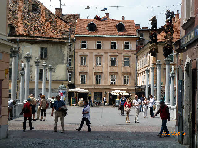
Many of the bridges have a long history. The
shoemakers bridge shown next was occupied by shoemakers following the eviction
of the butchers by popular petition to the ruling Emperor Maximilian 1st because
of the smell. Max was a depressive and used to take his coffin with him on his
travels. There are no shoemakers left, but the pile of shoes hanging up in the
top right hand corner represents their past glories.
However, another reason for being in the city
was to meet up with Jane’s nephew David who is doing research at Ljubljana University.
Here’s Jane and David in Prešernov Trg, one of the principal squares.
With a local guide, how could we fail to properly
check out the city? It’s not the guidebook stuff; anyone can get hold of that,
but the hidden corners. So now guess what this is.
A graffitied, derelict building? It’s certainly covered in
graffiti; in fact it’s a non-profitmaking cultural and social centre, a huge
7,000 square metre squat of the former premises of the State owned ROG bicycle
factory, closed in 1994. The organisers and users see this enterprise as
providing extensive cultural opportunities from an unused building, and you
have to ask the question, why not?
Bring your own bottle and fill it with
milk from the dispensing machine. It’s in the market square: fresh milk every
day, and cheap. What a great idea, but would it be too much bother for us back in
the UK?
We liked Ljubljana very much. It had a great
atmosphere and vibrancy. And not just the old quarter; the post 1895 earthquake
buildings are quality designs, like this department store, completed in 1905 in
the art nouveau style.
Saturday, 9 June 2012
To Slovenia 1st June: Lake Bled
Camping Bled is right on the Lake. It’s a large campsite, so our actual pitch is a few hundred metres from the lake, but you walk out of the site entrance onto the path that circles the lake. The town of Bled is at the opposite end to the campsite. It’s not a large lake, about 4 miles all round, but very picturesque. Here’s a view from the path with a tourist boat being rowed gondola-style, at gondola-style prices.
The other distinguishing feature of the lake is the island. This appears on every tourist ad for Bled and often for Slovenia itself. Can’t manage the usual helicopter shot, but this is it, the clump of green trees where the church is.
Something always seems to be going on. This weekend it’s the European Junior Rowing competition. The lake was sectioned into lanes along its total length for races. It was great to see all the youngsters keenly competing, and here are three boats speeding neck and neck for the finishing line. We decided not to take out a pedalo and show them what real speed was.
On the walk around the lake there is a long garden containing many unusual sculptures, the most bizarre of which is in the next photo. It’s a pyramid of fish-heads. You always look for some deep meaning in these sorts of works, but maybe it’s nothing more than a hint to the wife that he’s fed up with fish for dinner four times a week.
Wednesday, 6 June 2012
30th May: The Zumberak
This was our last trip out before leaving
Croatia, to a region located between the campsite and the Slovenian border. It
comprises remote villages and steep green hills. Buildings like this old mill
were typical.
There were also some beautifully simple small country churches as shown in the photo below.
None of our maps covered the area in enough detail to navigate the small country roads, so we used the sat-nav. Just put the name of the next village in and let the device do the work. We stopped at a lovely spot for lunch, in a valley by a stream, en route to the next destination. It was from there on that the trouble began. The road started to deteriorate and soon became a rubble-strewn, narrow, grass covered track that ascended steeply through dense forest. At one point the trees fell away down a steep ravine to reveal this lovely view.
Why do we have such blind faith in these gadgets? After 20
miles of crawling along the dirt track at no more than 10 miles per hour, the
sat-nav voice cheerfully announced: “Welcome to Slovenia.” It had taken us into
another country! We were expecting customs officers to appear through the trees
at any minute, and of course we had no passports with us. Was this an ancient
smuggling trail perhaps?
But plod on, having come so far we didn’t want to retrace
our steps on such an awful road. A sigh of relief- in a few miles, the sat-nav
welcomed us back to Croatia. Soon after, at a crossroads in the track, I was
able to reset a route to another and nearer village, still 6 miles away, but here
was a proper tarmac road, with lines on. It was like driving on a motorway.
Off-roading adventure not withstanding, we found the Zumberak a lovely area.
Just as we were running out of the hills, we passed another unusual small
church, complete with reflection, that could have been transported straight
from Russia. With love.Tuesday, 5 June 2012
Karlovac
Karlovac’ was built as a fortress town in 1579 by the Austrian Empire and contained many elegant buildings. A lot of these are now in a poor condition following the town’s decline after the Homeland War. This is a good example.
Some dwellings are also in a state of decay.
We’ve seen very few occupied properties in this condition in Croatia in general.
We know this one is being lived in from the lady hanging out washing, and the
sky dishes.
In my childhood it was not unusual to see
bombsites left from World War II, and similarly here we are seeing the
aftermath of a war. The main difference is the type of damage: here it’s often
the bullet holes of hand to hand fighting in the streets.
But let’s not portray a worse picture than it
is. It’s not all falling to pieces, so to prove it here’s a church tower and town
roofs all in good condition. Well, maybe a lick of paint on the bottom right
hand tower.
There was also a medieval pageant held at the
castle overlooking the town on the last weekend in May. The participants went
to great trouble to dress the part and provided all sorts of re-enactments,
like this dancing.
We found the most authentic presentation to be
the weapons fighting. A man and woman demonstrated their skills with swords,
daggers and pikes. They were highly accomplished. The photo shows the pike
fight. I imagine the combatants were in fact man and wife as she looks like she
really wants to kill him.
The Turk with his turned up toes and beard looks
the part, as do the children and the man in black and white picking his nose! Most
realistic, as they must have had bad (or worse) habits back in those days!
Subscribe to:
Posts (Atom)


