Wednesday, 28 March 2018

The Local Village, Isla Plana


The village name means “flat island”, and it lies a mile along the road from the campsite. It’s slightly longer by a much more scenic route via the beach. This way, you take a path alongside a rambla, a dry ravine, that runs down to the sea, and then walk along the beach. There is a path on both sides of the rambla, fairly close to the edge. Only after studying the photo underneath, do you realise how undercut the edge is. It’s a good 30 feet drop, so don’t jump about on the path.
At the end of the rambla a wooden stairs leads to the beach itself. We’re heading for the cluster of buildings in the distance.
20 minutes later we’re in the village, on the prom, and looking at some excavated Roman remains, apparently kilns. The flat island, after which the village is named, is in the background.
The most interesting structure in the village, and the one we come to next, is the old bath house: Los Banos de la Marrana. These were public baths opened in 1901, using water from hot thermal springs that had been on site for centuries.The baths fell into disuse in the 1950’s and are not now accessible inside, although on past visits we were able to enter and view the sad decay and graffiti. The exterior gives a much more satisfactory and picturesque appearance.
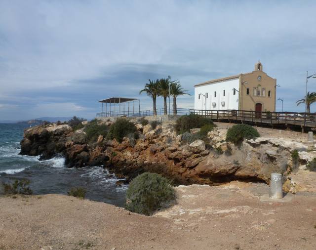
On a small headland is the church, the Ermita de Nuestra Senora del Carmen, patron saint of the sea. It was planned in 1928 but only built in 1960, so is relatively new. 

The church address is, strangely, Calle Elefante, Elephant Street, so could Hannibal have perhaps passed this way, maybe to take a bath.
The next photo shows our usual destination: the Pensionista. Originally set up as an old folks social venue, it’s now open to all as a very reasonably priced cafĂ©. The chairs and tables sprawl all over the front under the palm trees so there’s a lovely view of the coast and the church thrown in.
Isla Plana has plenty of small shops and a small supermarket, so we don’t need to go far for top-up shopping. Now it’s back down the beach to our caravan home to enjoy another exceptional evening light.


Sunday, 25 March 2018

The Walking Group


Once a week the group walks, generally starting a short car ride from the campsite. Jan and Maryon, a Dutch couple who live on site, are the organisers. It’s always a 10:30 am start, on the dot: latecomers are reprimanded!
We’re all on time, so no lines or detentions today, and drive to the start of a circular walk in the local hills about 10 miles away. Parking up at the bottom of the track, we set off. Parking is generally easy in Spain outside of the cities as there is so much unfenced scrub land available. We’re taking an early breather here, having just ascended a steep gradient.
Onwards and upwards on todays excellent path, a well maintained dirt road as can be seen from the photo above. Often our walks take us on ancient donkey tracks; however, as there aren’t too many ancient donkeys around these days, these routes are often crumbling in disrepair.

Looking down at this early stage in the walk it’s noticeable how green parts of the countryside are. In spite of the low annual rainfall in this area, the winter showers have greened up the flowers, shrubs and weeds.
It’s worth pointing out that the white bits in the picture are plastic greenhouses. They are everywhere in this region and used for forcing crops of strawberries, cucumbers, peppers and, above all, tomatoes. Higher up in the walk, the landscape takes on the arid appearance typical of southern Spain.
Now we’ve reached the highest point, still on good unmetalled roads, with a distant panorama as the air is so clear.
The roads are built on firm stone foundations and surfaced with compacted stone chippings, thereby easy to maintain. In the UK, we’ve always looked down on these as primitive, inferior carriageways. However, for local roads where speed and low traffic volume apply, would this form of construction not be preferable to our deeply potholed tarmac roads which cost a fortune to repair, money which councils say they haven’t got?  
Looking next at the panorama rather than our group, the sea is clearly visible about 10 miles away. No prizes for spotting the tomato greenhouses in the distance. Our road yet to travel is also visible on the left-hand hill.
The road enables access for people living in these hills, generally in smallholdings like the one beneath. The groups of buildings always look higgledy-piggley and poorly looked after, but maybe that’s of secondary importance to trying to scratch a living from this parched land. 
One further delight at this time of the year is the blossoming of the fruit trees. We guessed that this one was a cherry.
Back to the cars, and a coffee (or beer) stop on the way back: anothersplendid walk in lovely weather even if the wind had a cold edge to it.


Monday, 19 March 2018

Spain & France Spring 2018

Start: Monday 5th March

Snow and forecast high winds delayed our departure by four days, but then the journey proved quite straightforward . With 1,500 miles to travel we drove for three consecutive days through France to reach northern Spain, and then took a few days breather at a Dutch-owned site where we’ve stayed before. Set in cork oak country, it offers pleasant walks with the backdrop of the Pyrenees foothills.

The cork oaks themselves are harvested about every seven years by stripping the cork bark. This tree shows the line of the last stripping about 2/3 of the way up the main trunk.
We gathered a few pieces of discarded bark to take back with us, remembering this time to first knock the bugs out. The last occasion we filled the car with cork pieces from whence armies of insects emerged and colonised the car.
So onwards towards our final destination, Camping Los Madriles, 10 miles from the city of Cartagena in Murcia. The campsite looked as good as ever, and we were fortunate enough to take over a prime pitch from our friends Stan and Ela who were leaving. This is the view from our caravan window.

A short walk takes us from the site to the sea and walks on good paths for several miles in either direction. This is the same scene as from the caravan window but from the coast track.
At the side of the site is a rambla, a dry river bed, that is used as a dirt road for access. The lush vegetation, supported by the occasional deluge that funnels through the rambla, contrasts with the stark hills behind. This is the driest part of Spain with about 8 inches (20 cms) of rain a year.
The rambla runs for around 5 miles and supports large numbers of birds that live in the improved habitat. It’s a really scenic walk, one of our favourites, where we can bird-watch as well as enjoy the surroundings.
In the few days since arriving we have met many campers we know from past visits. All things considered, we look forward to a pleasant couple of months here. 


Sunday, 29 October 2017

Silverwood lake

We’ve had a lot of desert in the last few weeks. They’re hot and dry, with resident creatures that are seldom seen. Today, for a change, we’re going to a lake and we’ll have green areas near the water that may attract more animals and birds.

This is Silverwood lake, a reservoir created in 1971 in the San Bernardino Mountains that is run as a California State Park.
 We arrive near the lake shoreline and there are lots of birds, many of which we’ve seen before, but plenty to observe nonetheless. One dfferent species is the Acorn Woodpecker. We see numbers of them tapping away at certain trees. This is one of them- what is it doing?
Magnifying the image, the tree is peppered with holes: the woodpecker is storing food for winter in the tree bark.
Being an Acorn Woodpecker, it’s storing acorns, but the size of these acorns is something else. Jane is holding one in her hand.
The lakeside walk is delightful, and on an easy  tarmac path.
There are pleasant views wherever you look, and very peaceful. Black bears are reputedly in the area but none seen. Clearly all are somewhere in the woods on a picnic.
At this point, it’s worth comparing our previous day’s walk in Mule Canyon near the campsite. This is the desolate entrance to Mule Canyon. We saw lots of off-roaders, but no mules.

Looking back down the canyon we see dust-devils swirling off a dried-up lake bed. It’s next to a rattlesnake conservation area- but we didn’t see any of those either. 
But back to Silverwood. The lake isn’t named after a type of tree, but after a certain Ted Silverwood who was a local conservationalist. The trees were especially beautiful as many were showing signs of autumn colours: with the lake being at 3,500 feet they would already have got some colder nights. 
Yes, a splendid day out. Tomorrow we head for Las Vegas and are handing back the motorhome on Thursday 26th October. In spite of running over the block of wood, we’ve had a great adventure. 


Monday, 23 October 2017

Calico Ghost Town

Ghost towns are big business in America. Of course, when you visit one, it’s anything but a ghost town. The idea is to give you the atmosphere of the original town that was abandonned and at the same time have shops and attractions that tourists love which may have little connection with that
original town.

Here’s our local contender, Calico, close to our campsite here in Barstow, California. The campsite even runs a free shuttle up to Calico.
Note the obligatory narrow gauge steam train in the background.
The community of Calico started in 1881 with the discovery of silver. It grew rapidly until the price of silver halved in 1907, following which the town was practically abandoned. It regenerated briefly in 1915 with a recovery of silver prices; that was also when a young carpenter called Walter Knott came to work in the town. More about Walter shortly. The original town looked like this.
This is looking up the main street as it is today.
Calico went into a permanent decline after 1915 and Walter Knott moved on. By the 1940’s he had built his own sucessful theme park business, that included a ghost town. He liked ghost towns,  so in 1951 he bought Calico, now in advanced decay, to restore it, which he did using original plans and photos. In 1966 he donated Calico to San Bernadino County who still own and run it.
The school house can be recognised in the old photo, at the top of the hill.
The town has several museums containing items from Calico’s early days, including some unusual curiosities like this wooden bath. You’d have to be really quick before the water ran out of the cracks.
The old fire engine looks the part, Keystone Cops style, but was essential in a wooden town with wood stoves for heating and cooking. Calico had several serious fires.
Being a mining town, facilities were basic in the early years. Some dwellings were constructed around hollows or caves in the rocks.
Inside is about what you would expect.
 There are 30 miles of old mine workings, but only one safe enough to walk through unescorted. It was a tough life mining ore but wasn’t as primitive as you might imagine; they had some compressed-air tools powered by a steam compressor.  
We don’t realise how big Halloween is in the USA. Shops were already selling Halloween goods in August when we arrived, and Halloween parties and events are advertised from mid October. Needless to say, in Calico – remember it’s a ghost town- they go overboard. The town is festooned with spectral figures, skeletons and pumpkins. Can’t imagine that being haunted by a pumpkin is very scary. For us, it took away the "olde mining towne" image a bit, and my photos minimise the Halloween paraphernalia. However, it’s the American thing, and they do it very well, so here’s an example of someone you don’t want to bump into when driving home on a dark night.
It was an interesting visit, but with a few reservations (not Indian ones this time). The town seemed to be more about tourist shops than its history, and some of the restoration owed more to theme park imagination than period accuracy. In fact, the one building that survives intact, from 1885, looks fairly ordinary- not what attract the visitors. 
As we were leaving, the wind started to get up. By the following day it had turned into a full scale dust storm. This picture of the motorway near the campsite was taken after the worst had passed.


Saturday, 21 October 2017

Lake Havasu

We’ve got the motorhome back, duly repaired, and head for a chill-out week at Havasu City, a holiday resort in the Mohave desert. It was founded in 1964 and developed largely by the Robert McCulloch corporation. Most Brits have never heard of it, but would be familiar with its main tourist attraction- London Bridge!
By the 1960’s London Bridge was unable to cope with modern traffic, so was put up for sale. It was bought in 1968 by McCullough as a feature for his ongoing project at Havasu. Rumour has it that he thought he was buying Tower Bridge, a much more recogniseable structure.
He paid $2.5 million and then spent another $7 million in shipping and reconstruction. We weren’t that impressed (we have a much  older bridge at Alconbury!) but it is a focal point that attracts many holidaymakers and weekenders, particularly boaters.
 Havasu City’s existence as a holiday resort is totally reliant on the 45 mile long lake of the same name created in 1938 by damming the Colorado River. It’s wide enough and long enough that the speedboats can run at top speed along the centre of the lake.
Some of the speedboats are really powerful. This is one, close up, on the forecourt of a big repair yard just in front of the campsite. When they throttle up the monster engines, that seem not to have silencers, the whole campsite vibrates. Good earthquake training.
But let’s not be a spoil-sport; the campsite is just up from the lake shore that is most pleasant to sit by or walk along. Temperatures are in the mid 90's F (35 C) for the whole week.
The rapid tropical sunset gives some unusual shots of the palm trees in the dying light.
There is another Havasu: the nature reserves. In the northern reserve, 30 miles from the resort, we saw absolutely no-one. It’s not part of the main lake  and is maintained as shallow pools with creeks and marshes.
However, it wasn’t exactly teeming with wildlife, but we did see various birds, including a roadrunner, and also a coyote. He waited for me to point the camera, unlike the others.
Some of the original trees were visible sticking out of the water, a stark picture against the jagged mountains.
The temperature here is hovering near 100F, so we leave the mosquitos to pester someone else, and the animals to their shady resting places.

On another day we head 30 miles south along the lake shore. This reserve here is part of the main lake but joins onto the reed beds of the Bill Williams River that runs into the lake at this point. Bill Williams was a trapper and frontiersman, definitely not the Bill Williams I knew that ran our school sweet shop.
There are many more birds here. Again it’s very hot. We need to watch where we’re walking.
Fortunately, we don’t see any rattlesnakes, but apparently there are plenty around. We go farther into the reserve on a dirt road, but it’s too rough for the hire car really, so we proceed on foot. It gets bleaker and more remote. We are at the meeting place of two deserts, the Mohave and the Sonora. It’s too hot to walk any further, so we go back to the car.  
Our week at Havasu gave us a refreshing rest, and we left on Tuesday, 17th Oct, for Barstow in California.