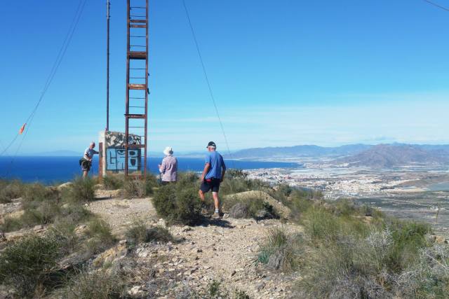
Tuesday, 24 April 2018

The Custom House

Although referred to locally as the Custom House, I have been unable to uncover any of its history. It’s a pleasant walk along a dirt road that once provided access to the building that stands overlooking the sea. We start from the Cantina in Campillo de Adentro, a tapas bar. The greasier the tapas, the more authentic the bar. This one is really authentic. 

On the outskirts of the village we pass an abandonned Spanish military building. In this area there are many such buildings, all associated with the gun batteries on a headland several miles away that operated from the late 1920’s to 1993. They all look like Foreign Legion filmset forts.
A short way along the gravel road we spy a huge bright yellow mound, emitting a sweet sharp smell. Rudi investigates and finds that it’s a pile of dumped minced-up lemons. Just one whole specimen survives that Rudi has claimed. There are no lemon trees within several miles so some processing plant has clearly fly-tipped them. 
But let’s move on as we have three miles to go and some 800 feet of elevation to climb before we drop down to the Custom House itself. This is the highest point on the road from where we can now view the sea and rugged coastline. The road surface is little used but quite good.
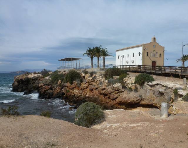
The Custom House setting is idyllic. There is no natural water on this part of the coast so perhaps the customs men had to make do with beer or wine. Working conditions were tough then.
The building itself is securely boarded up, presumably to prevent squatters, but is in good condition. What a shame that it cannot be used as a walkers hostel, being on a major coastal footpath route. 
The views from the large front patio area, railed off for safety, are spectacular. It would be a wonderful location for backpackers and ramblers to spend time at.
To one side of the building are several small stone structures that could be animal shelters if they were larger. They aren’t shrines either – any guesses? 
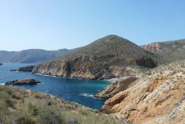
We look along the coast path we now need to follow. It’s certainly picturesque, but where’s the path? We are heading for the small bay just visible before climbing up to the rocks on the skyline.
A look back at the Custom House shows what an isolated place it is. Let’s hope the customs officers had plenty of smugglers to catch to avoid boredom.
We eventually find and follow the waymarked path to the beach where there are some interesting rock formations on the exit track. 
After this, the going isn’t so easy on the ascent to the rocks. This is typically how the path looks and was even steeper in parts.
We plod on, to hit a point on the military road about 900 feet above sea level where we had parked a second car. We can just pick out the beach, where we started to climb, way below in the distance.  That was some walk!


Friday, 13 April 2018

Oven Peak


It sounds more dignified in Spanish: Cabeza del Horno. It’s directly behind the campsite and is a steep ascent in parts. The photo is taken from our pitch.
The hill is a good fitness test and takes about an hour from the campsite to the top. So here are today's intrepid challengers proceeding along the outside of the campsite heading for the base of the hill. It’s all scrub land with networks of pipes running here and there without any clear purpose.
It’s quite a scramble, but we reach the top in the obligatory hour. There’s a fine panorama of the bay and the campsite where Jane and some friends have just finished aquarobics in the pool and are claiming to be waving to us. 
I really couldn’t spot them at the time but, sure enough, in the telephoto picture examined later- there they are, top left corner on the green part (the artificial grass). 
This is the mast, clearly visible from below, but no longer functional, looking somewhat like a guillotine. Lucky it’s not functioning then. Rudi’s found a door in the tin shed just behind the mast. “Order four café con leches and a plate of churros while your in there”, I shout to Rudi. Sadly the potential hilltop café isn’t functioning either. We have a swig of our tepid water instead. 
Nice view, looking inland, of the rambla and White Cliffs where we walked a few days ago.
Having taken in the 360 degree vista, we start to descend down the back of the hill, using the road originally made to build and then maintain the mast when it was operational. It’s deteriorated significantly, with weathered ruts and rubble but at least it leads in the right direction to get back down again.
The disused road decants us in Isla Plana village. On the outskirts is a crumbling, derelict house. It is interesting to note from the partly collapsed wall how it was constructed- evidently of local stone with very little cement or mortar just like a dry stone wall. 
We have a purpose, and head towards the Pensionista café in Isla Plana to meet up with our cheerleaders, the aquarobics team, for coffee. We have all earned our refreshments this morning!


Friday, 6 April 2018

Bol Nuevo


This small town is on the other side of Mazarron bay from the campsite, and features fantastic sandstone shapes carved by wind and weather over the centuries. The Tourist Board refers to it as “La Ciudad Encantada”, The Enchanted City, which is over egging it a bit, but attracting visitors is a competitive business.
The town itself is pleasant but unremarkable, and we drive through it until the tarmac road runs out at a car park just the other side. There’s a pretty sea view in the direction of where we intend to walk.
Since visiting last time, some years ago, sturdy wooden handrails have appeared along the sea edge of the gravel road so you can’t now leap out of the way of manic car drivers. Most local improvements of this type, we are told, are funded by Eurogrants.
 Looks like the euro money ran out here, but the sandstone column probably looks more dramatic without the wooden railings.

The dirt road is really a wonder of construction. Long before EC grants existed, a cleft was blasted through this a rock.
The road is never far from the coast, which is all small headlands and bays, like the one in the next photo. Many of the coves are nudist beaches, so wear dark glasses if you don’t want to be put off your lunch.
There are some family beaches- but which is which? At this next one we furtively take a short break before returning to the car park. Luckily, no wobbly bits appear from rocky hiding places.  
This part of the return looks like we’re following a castle wall. It’s the wind-blown sandstone again.
 Although there were no habitations of any sort on the walk, arriving back near the car park we noticed several opulent dwellings. This one continues the castle theme of the previous photo. 
So we complete a very pleasant seaside walk. Bol Nuevo means New Bowl, which begs the question as to what the Old Bowl or Original Bowl was like.


Monday, 2 April 2018

Espuña Regional Park


Today we are walking in Espuña, a small range of wooded mountains with good footpaths an hour’s drive from the campsite. The radar dome on the cliffs in  the photo below is at the highest point, 5,200 feet above sea level. So our walk starts near the top; conveniently, a public road goes almost to the radar station and finishes at a car park.
They might be good paths, but they can be quite steep as this next gradient shows. It’s good for warming up though as the air is much cooler at this height than on the coast where we started out.
The views are worth the effort, especially as we look north to much higher mountains that are still snow-capped.
An odd feature of the mountain park is the large number of ice-houses dotted around, a few restored like the one in the photo underneath, but most in ruins. There were originally 25, serving the cities of Murcia and Cartagena that are fairly close by.
The ice-houses operated for three and a half centuries, until 80 years ago when refrigeration came. Snow was compacted to a depth of 7 metres, up to the level of the door, with the dome an empty air chamber. This kept the ice at the lowest temperature. The inside holds a large volume as can be seen from the photo.
We didn’t catch site of the mouflon herds this time, long horned sheep re-introduced into the park, or the wild boar which are quite plentiful. Right at the end, though, we did see a peculiar, snake-like, thin, moving line. What was it?
On closer inspection it turned out to be a nose-to-tail line of caterpillars, as the close-up photo reveals. It all looks very endearing, like a parade of tiny elephants. But there’s a definite sting in the tail!
These are pine processionary caterpillars whose young nest in pine trees in silky web pouches that damage and can kill the trees. Also, DO NOT TOUCH the caterpillars as they give off fine hairs that cause throat swelling  resulting in breathing difficulties, especially so for asthma or bronchial sufferers. It can be fatal to dogs. Advice is to call in pest control who wear contamination suits and burn the nests. So not so sweet after all- but this is one object of the walks, to see interesting and different things.

We did spot a fox later, outside the restaurant where we stopped for lunch, but it was gone before cameras could be uncased. Even the restaurant chef shot out to see it, not brandishing a meat cleaver, as you might expect, but with some food for it in his hand. Perhaps the meat cleaver was hidden in his apron.


Wednesday, 28 March 2018

The Local Village, Isla Plana


The village name means “flat island”, and it lies a mile along the road from the campsite. It’s slightly longer by a much more scenic route via the beach. This way, you take a path alongside a rambla, a dry ravine, that runs down to the sea, and then walk along the beach. There is a path on both sides of the rambla, fairly close to the edge. Only after studying the photo underneath, do you realise how undercut the edge is. It’s a good 30 feet drop, so don’t jump about on the path.
At the end of the rambla a wooden stairs leads to the beach itself. We’re heading for the cluster of buildings in the distance.
20 minutes later we’re in the village, on the prom, and looking at some excavated Roman remains, apparently kilns. The flat island, after which the village is named, is in the background.
The most interesting structure in the village, and the one we come to next, is the old bath house: Los Banos de la Marrana. These were public baths opened in 1901, using water from hot thermal springs that had been on site for centuries.The baths fell into disuse in the 1950’s and are not now accessible inside, although on past visits we were able to enter and view the sad decay and graffiti. The exterior gives a much more satisfactory and picturesque appearance.
On a small headland is the church, the Ermita de Nuestra Senora del Carmen, patron saint of the sea. It was planned in 1928 but only built in 1960, so is relatively new. 

The church address is, strangely, Calle Elefante, Elephant Street, so could Hannibal have perhaps passed this way, maybe to take a bath.
The next photo shows our usual destination: the Pensionista. Originally set up as an old folks social venue, it’s now open to all as a very reasonably priced café. The chairs and tables sprawl all over the front under the palm trees so there’s a lovely view of the coast and the church thrown in.
Isla Plana has plenty of small shops and a small supermarket, so we don’t need to go far for top-up shopping. Now it’s back down the beach to our caravan home to enjoy another exceptional evening light.


Sunday, 25 March 2018

The Walking Group


Once a week the group walks, generally starting a short car ride from the campsite. Jan and Maryon, a Dutch couple who live on site, are the organisers. It’s always a 10:30 am start, on the dot: latecomers are reprimanded!
We’re all on time, so no lines or detentions today, and drive to the start of a circular walk in the local hills about 10 miles away. Parking up at the bottom of the track, we set off. Parking is generally easy in Spain outside of the cities as there is so much unfenced scrub land available. We’re taking an early breather here, having just ascended a steep gradient.
Onwards and upwards on todays excellent path, a well maintained dirt road as can be seen from the photo above. Often our walks take us on ancient donkey tracks; however, as there aren’t too many ancient donkeys around these days, these routes are often crumbling in disrepair.

Looking down at this early stage in the walk it’s noticeable how green parts of the countryside are. In spite of the low annual rainfall in this area, the winter showers have greened up the flowers, shrubs and weeds.
It’s worth pointing out that the white bits in the picture are plastic greenhouses. They are everywhere in this region and used for forcing crops of strawberries, cucumbers, peppers and, above all, tomatoes. Higher up in the walk, the landscape takes on the arid appearance typical of southern Spain.
Now we’ve reached the highest point, still on good unmetalled roads, with a distant panorama as the air is so clear.
The roads are built on firm stone foundations and surfaced with compacted stone chippings, thereby easy to maintain. In the UK, we’ve always looked down on these as primitive, inferior carriageways. However, for local roads where speed and low traffic volume apply, would this form of construction not be preferable to our deeply potholed tarmac roads which cost a fortune to repair, money which councils say they haven’t got?  
Looking next at the panorama rather than our group, the sea is clearly visible about 10 miles away. No prizes for spotting the tomato greenhouses in the distance. Our road yet to travel is also visible on the left-hand hill.
The road enables access for people living in these hills, generally in smallholdings like the one beneath. The groups of buildings always look higgledy-piggley and poorly looked after, but maybe that’s of secondary importance to trying to scratch a living from this parched land. 
One further delight at this time of the year is the blossoming of the fruit trees. We guessed that this one was a cherry.
Back to the cars, and a coffee (or beer) stop on the way back: anothersplendid walk in lovely weather even if the wind had a cold edge to it.