Tuesday, 1 May 2018

The Rambla del Cañar


This is the best inland walk, right by the campsite. It’s a dry river bed five miles long with a dirt access track running right through and out the other end. Parts of the rambla are ravine-like, running through barren hills. There is lush vegetation in the rambla itself from the occasional downpour that reawakens the watercourse; in addition, there is  a permanent 
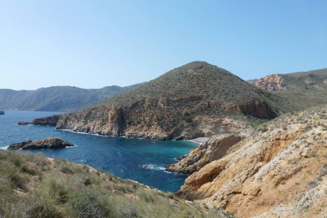
spring. This is a sample of the terrain. The black hole is the cave of the horseman, a stiff climb for a mountain goat never mind a horse.
Further up, the rambla widens out with a backdrop of 2,000 foot chalk-white cliffs, minus the bluebirds.
There is more water here than in other parts of the region, and even more water in past times so we are told, so there was substantial agriculture in the rambla area. Some of the old farm dwellings survive, the inhabitants still scratching a living as in the photo below; other houses have been modernised and extended as homes for city people or foreigners.
But many have fallen into disrepair, in some cases just piles of stones. This premises has clearly been vacant for many years but retains its structure; it is bigger than it appears from the photo as it extends to the back. The high room on the right is unconnected to the main building and contains a fire place but with alcoves and round windows as in a chapel. 
Some of the roof beams were exposed at the back showing the rough tree trunks used, presumably available locally.
The land formerly cultivated behind the farmhouse is still green, but not planted with any crop, in a really beautiful setting.
There is, in fact, a proper chapel near the top of the rambla, a tiny place of worship attached to a small recreation hall. We sat on the benches outside to eat our sandwiches accompanied by a friendly local dog who thought we might have a spare sandwich.
The spring, mentioned earlier, still flows, and was first recorded in Roman times. This is it, not highly impressive, but it’s at least a reliable water supply.
In the past the spring water was channelled through a network of pipes and gullys for irrigation purposes and also to run a corn mill. This, above all, proves the historic fertility of the rambla. This water channel provided the water power for the mill, located about a mile down from the spring.
This water then drops some 30 or 40 feet down a hole onto a waterwheel connected to the grinding mechanism. Can’t help thinking the hole looks like a medieval castle toilet.
This is what remains of the mill from the lower level. Its description comes courtesy of an information board: you just couldn’t guess what it had been otherwise.
There are some unusual visitors at this time of the year, the bee-eaters who  feed off bees that live in holes in the soft mudstone cliffs to be found in the lower parts of the rambla. 
The bee-eaters are most colourful, like parrots, but difficult to photograph. The next two photos will at least give some idea of their vivid appearance. They are about starling size.

Well, enough of rambling on about the rambla. It’s a fascinating place with always something new to offer. It has a long mining history, for example, but that’s for another time.

We leave here on Thursday, May 3rd, slowly heading back up the Med coast into France. Will keep posting anything of interest as we go along.


Tuesday, 24 April 2018

The Custom House

Although referred to locally as the Custom House, I have been unable to uncover any of its history. It’s a pleasant walk along a dirt road that once provided access to the building that stands overlooking the sea. We start from the Cantina in Campillo de Adentro, a tapas bar. The greasier the tapas, the more authentic the bar. This one is really authentic. 

On the outskirts of the village we pass an abandonned Spanish military building. In this area there are many such buildings, all associated with the gun batteries on a headland several miles away that operated from the late 1920’s to 1993. They all look like Foreign Legion filmset forts.
A short way along the gravel road we spy a huge bright yellow mound, emitting a sweet sharp smell. Rudi investigates and finds that it’s a pile of dumped minced-up lemons. Just one whole specimen survives that Rudi has claimed. There are no lemon trees within several miles so some processing plant has clearly fly-tipped them. 
But let’s move on as we have three miles to go and some 800 feet of elevation to climb before we drop down to the Custom House itself. This is the highest point on the road from where we can now view the sea and rugged coastline. The road surface is little used but quite good.
The Custom House setting is idyllic. There is no natural water on this part of the coast so perhaps the customs men had to make do with beer or wine. Working conditions were tough then.
The building itself is securely boarded up, presumably to prevent squatters, but is in good condition. What a shame that it cannot be used as a walkers hostel, being on a major coastal footpath route. 
The views from the large front patio area, railed off for safety, are spectacular. It would be a wonderful location for backpackers and ramblers to spend time at.
To one side of the building are several small stone structures that could be animal shelters if they were larger. They aren’t shrines either – any guesses? 
We look along the coast path we now need to follow. It’s certainly picturesque, but where’s the path? We are heading for the small bay just visible before climbing up to the rocks on the skyline.
A look back at the Custom House shows what an isolated place it is. Let’s hope the customs officers had plenty of smugglers to catch to avoid boredom.
We eventually find and follow the waymarked path to the beach where there are some interesting rock formations on the exit track. 
After this, the going isn’t so easy on the ascent to the rocks. This is typically how the path looks and was even steeper in parts.
We plod on, to hit a point on the military road about 900 feet above sea level where we had parked a second car. We can just pick out the beach, where we started to climb, way below in the distance.  That was some walk!


Friday, 13 April 2018

Oven Peak


It sounds more dignified in Spanish: Cabeza del Horno. It’s directly behind the campsite and is a steep ascent in parts. The photo is taken from our pitch.
The hill is a good fitness test and takes about an hour from the campsite to the top. So here are today's intrepid challengers proceeding along the outside of the campsite heading for the base of the hill. It’s all scrub land with networks of pipes running here and there without any clear purpose.
It’s quite a scramble, but we reach the top in the obligatory hour. There’s a fine panorama of the bay and the campsite where Jane and some friends have just finished aquarobics in the pool and are claiming to be waving to us. 
I really couldn’t spot them at the time but, sure enough, in the telephoto picture examined later- there they are, top left corner on the green part (the artificial grass). 
This is the mast, clearly visible from below, but no longer functional, looking somewhat like a guillotine. Lucky it’s not functioning then. Rudi’s found a door in the tin shed just behind the mast. “Order four café con leches and a plate of churros while your in there”, I shout to Rudi. Sadly the potential hilltop café isn’t functioning either. We have a swig of our tepid water instead. 
Nice view, looking inland, of the rambla and White Cliffs where we walked a few days ago.
Having taken in the 360 degree vista, we start to descend down the back of the hill, using the road originally made to build and then maintain the mast when it was operational. It’s deteriorated significantly, with weathered ruts and rubble but at least it leads in the right direction to get back down again.
The disused road decants us in Isla Plana village. On the outskirts is a crumbling, derelict house. It is interesting to note from the partly collapsed wall how it was constructed- evidently of local stone with very little cement or mortar just like a dry stone wall. 
We have a purpose, and head towards the Pensionista café in Isla Plana to meet up with our cheerleaders, the aquarobics team, for coffee. We have all earned our refreshments this morning!


Friday, 6 April 2018

Bol Nuevo


This small town is on the other side of Mazarron bay from the campsite, and features fantastic sandstone shapes carved by wind and weather over the centuries. The Tourist Board refers to it as “La Ciudad Encantada”, The Enchanted City, which is over egging it a bit, but attracting visitors is a competitive business.
The town itself is pleasant but unremarkable, and we drive through it until the tarmac road runs out at a car park just the other side. There’s a pretty sea view in the direction of where we intend to walk.
Since visiting last time, some years ago, sturdy wooden handrails have appeared along the sea edge of the gravel road so you can’t now leap out of the way of manic car drivers. Most local improvements of this type, we are told, are funded by Eurogrants.
 Looks like the euro money ran out here, but the sandstone column probably looks more dramatic without the wooden railings.

The dirt road is really a wonder of construction. Long before EC grants existed, a cleft was blasted through this a rock.
The road is never far from the coast, which is all small headlands and bays, like the one in the next photo. Many of the coves are nudist beaches, so wear dark glasses if you don’t want to be put off your lunch.
There are some family beaches- but which is which? At this next one we furtively take a short break before returning to the car park. Luckily, no wobbly bits appear from rocky hiding places.  
This part of the return looks like we’re following a castle wall. It’s the wind-blown sandstone again.
 Although there were no habitations of any sort on the walk, arriving back near the car park we noticed several opulent dwellings. This one continues the castle theme of the previous photo. 
So we complete a very pleasant seaside walk. Bol Nuevo means New Bowl, which begs the question as to what the Old Bowl or Original Bowl was like.


Monday, 2 April 2018

Espuña Regional Park


Today we are walking in Espuña, a small range of wooded mountains with good footpaths an hour’s drive from the campsite. The radar dome on the cliffs in  the photo below is at the highest point, 5,200 feet above sea level. So our walk starts near the top; conveniently, a public road goes almost to the radar station and finishes at a car park.
They might be good paths, but they can be quite steep as this next gradient shows. It’s good for warming up though as the air is much cooler at this height than on the coast where we started out.
The views are worth the effort, especially as we look north to much higher mountains that are still snow-capped.
An odd feature of the mountain park is the large number of ice-houses dotted around, a few restored like the one in the photo underneath, but most in ruins. There were originally 25, serving the cities of Murcia and Cartagena that are fairly close by.
The ice-houses operated for three and a half centuries, until 80 years ago when refrigeration came. Snow was compacted to a depth of 7 metres, up to the level of the door, with the dome an empty air chamber. This kept the ice at the lowest temperature. The inside holds a large volume as can be seen from the photo.
We didn’t catch site of the mouflon herds this time, long horned sheep re-introduced into the park, or the wild boar which are quite plentiful. Right at the end, though, we did see a peculiar, snake-like, thin, moving line. What was it?
On closer inspection it turned out to be a nose-to-tail line of caterpillars, as the close-up photo reveals. It all looks very endearing, like a parade of tiny elephants. But there’s a definite sting in the tail!
These are pine processionary caterpillars whose young nest in pine trees in silky web pouches that damage and can kill the trees. Also, DO NOT TOUCH the caterpillars as they give off fine hairs that cause throat swelling  resulting in breathing difficulties, especially so for asthma or bronchial sufferers. It can be fatal to dogs. Advice is to call in pest control who wear contamination suits and burn the nests. So not so sweet after all- but this is one object of the walks, to see interesting and different things.

We did spot a fox later, outside the restaurant where we stopped for lunch, but it was gone before cameras could be uncased. Even the restaurant chef shot out to see it, not brandishing a meat cleaver, as you might expect, but with some food for it in his hand. Perhaps the meat cleaver was hidden in his apron.