Wednesday, 14 November 2018

Nov 8th: Hola Mexico!


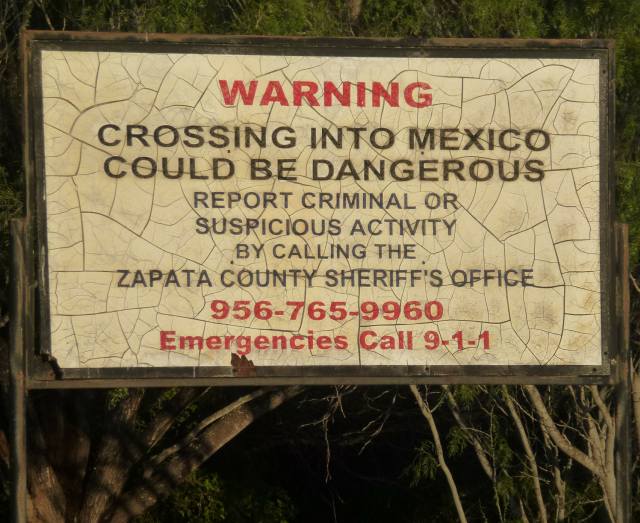
General advice is, don’t go to Mexico as the border towns are too dangerous: banditos likely to rob you, or caught in a shoot-out between rival drug gangs. We’re told that the Wild West still survives here on the Mexican border.

Delving into folk’s actual experiences of crossing into Mexico, it seemed there is one tame town called Progreso that also happens to be close to where we’re staying. So we decide to go, and drive to the crossing point, parking the car on the US side, then walking across the bridge spanning the Rio Grande. It feels like the covered bridge into Peterborough Queensgate Centre from the railway station side car park.


At the halfway point across the river is a plaque that marks the exact frontier line. The boundary was always the centreline of the river but in years of flooding in these flatlands the river would change course and, with it, the border. It is said that a certain chapel changed sides many times over several centuries. The Boundary Commission finally agreed in 1970 how this issue was to be resolved.
At the end of the bridge you walk straight into Progreso. It’s a fully committed tourist town with garish signs and vendors everywhere.
Over and above the expected shops and stalls are a large number of dentists, evidently charging much less than back across the bridge. Would you want to take the chance, though, and end up with a set of teeth that only speak Spanish. Numerous pharmacies, as well, since meds are also much cheaper on this side. Eyecatching rather than tasteful is the order of the day- isn’t that right, Pancho?
The bazaar style sidewalks could be in any of the poorer countries like Morocco or India. They offer their wares as you pass but here don’t pester if you say, “no thanks”.  That is different from Morocco where they sometimes grab your arm or chase after you. 
The one department store sets itself above the other traders, selling slightly better tourist tat. These Mexican dresses are very colourful, but I can’t really see Jane turning up in one to WI back in Alconbury.
We finish off in the department store café, chatting to two Texans (clue: the hats). In the background is some local mood music, and we had a decent cup of coffee.
Crossing back into Texas, the passport formality on the US side only took a few minutes. We didn’t feel uneasy or threatened at any time in Progreso, but then it was full of American tourists, the town’s income source, so why would they want to jeopardise that? To underwrite the security, we were told that there is an armed guard presence, the Rurales, but we didn’t notice any.


Definitely a day out with a difference, and we didn’t even buy a sombrero. Hasta la vista! 


Sunday, 11 November 2018

LLano Grande Resort


Leaving Falcon for Llano Grande, the landscape is still scrub. Gradually we see some grass emerging that evidently supports ranching as there are now a number
of traditional ranch signs like the one below.
Then a further change as we roll along, into crops as well as grass. We have reached the region known as the Rio Grande Valley, the final 50 miles of southern Texas, and a fertile year-round area of agricultural production. It’s an odd name because it’s not a valley but dead flat, and the Rio Grande runs along the whole 1,250 mile Texas border not just the last 50.


The Llano Grande campsite is big. We are pitch 612, but there’s plenty of room as the “snowbirds” haven’t all yet arrived from northern states or Canada. This is us, with the travel poster back. One year we had a realistic road graphic on the motorhome and needed to watch in foggy weather that someone didn’t try to drive along it.
The photo is taken from a bank, a levee, which used to be the Rio Grande before it changed course. A long lake is left that looks attractive in the evening light.
The birds also like the lake for night roosting. They arrive in hundreds, anything from small wading birds to pelicans.
Here are the last of them arriving in the setting sun that looks like a glowing mushroom.
Running alongside the levee lake is yet another state park, and one that we can walk to. Having already bought the park pass for our previous visits and stays, it’s free for us to come and go as we wish. There’s an alligator lake in the park but we failed to spot any from the viewing platform. My theory is that they all hide under the platform. Plenty of birds, though, and trying not overdo the bird aspect for non-birders, the next 3 photos are, in order, black belly whistling ducks, black and white stilt, and yellow crowned night heron. The ducks really do whistle; I’m sure the tune is Colonel Bogie.


Running along the levee top is a good path, sufficient to take a vehicle, which are not permitted, but they do allow walkers, bikers and golf trolleys. All campers here seem to have a golf trolley, to be used for all journeys of over 10 yard. Nobody walks much. People take their dogs for walks while driving the golf trolley. The dog runs alongside. Here’s one approaching in the distance, with trotting dog that probably isn’t close enough to be visible.
Got to say it, the showers and toilets are modern, clean, and greatly appreciated.
Sorry, state parks.


Friday, 9 November 2018

Lake Casa Blanca & Lake Falcon


From Seminole we drive south, following the Mexican border. 200 miles down the road is Laredo and lake Casa Blanca, another state Park where we’re staying for two nights to break the journey. It’s a pleasant stop, with plenty of pitch space. The lake and fishing pier takes a good photo in the late sunlight, with a heron on the pier.
The park is mainly aimed at boaters and fishermen, but has some wildlife interest like roadrunners and water birds, including osprey. We also came across this odd Spanish style building. Apparently an ex-museum, unused and boarded up, but structurally solid. Pity it can’t be used for the fisherman, or for general recreation, or even a café.
The state parks, including the camping areas, are generally well run with the exception of the toilet/shower facilities. These Spartan blocks, of assorted layouts and sizes, were clearly designed by boot camp architects. For example, communal men’s showers at one campsitel! Toilet doors often had no locks, and Jane’s showers provided a dead scorpion plus an enormous dangling spider. Shower curtains missing in many showers. We’re adventurers at heart, so no big problem; anyway, the state parks are cheap and the wildlife fascinating.


We leave Casa Blanca and travel the 100 miles to Falcon Lake for a three night stay. This is a wildlife visitors to our pitch, a peccary or javelina, a small hog. It’s edible, but no guns allowed in the parks, so the javelina lives to grunt another day. Its Spanish name comes from the javelin-sharp teeth that it will use, with tusks, if cornered. 

The Mexican border runs across Falcon Lake that was created by damming the Rio Grande River. The frontier runs down the centre a mile away, so it’s Trump’s front line so to speak. Plenty of police and Border Patrol vehicles around, but that’s no different from previous years when we’ve been along the frontier at the California/Arizona end.  The US also use surveillance balloons in this area that use radar equipment to detect drug and illegal immigrant activity. This isn’t a new Trump initiative as they’ve been in operation for some years. This is what they look like at ground level.
As if to emphasise that border issues go way back, here’s this cracked and yellowed notice from Falcon Lake. When the notice was put up the sheriff was probably still patrolling on a horse.
Our mobile phones pinged, “Welcome to Mexico”. Our calling plans allow internet use in the USA and calls back home at no extra charge. But the phone will pick up the strongest signal, and here that’s coming from Mexico. If you then use the phone it’s £2.00 per minute for calls and similar stiff fees for other services. Solution: turn off phone immediately.


However, birdsong was free. This is a vermilion flycatcher on a dark afternoon.
Nice walks on good paths, so you can see where you’re stepping (rattlesnake country). In most parts, the scrub is so thick the lake is hidden. That’s me by the tree, not an illegal immigrant. He’s taking the photo.
Falcon is awash with butterflies, especially in their butterfly garden. Texas has more species than any other state. One particular bush, the Rio Grande Bee-bush attracts them in their hundreds.
 Lots more birds, including an osprey eating its fish on the telegraph pole by our pitch, so a great back-to-nature time, but after three state parks one after the other we are ready for the comforts of a good commercial site. We now head for the southern tip of Texas, near the Gulf of Mexico, to Llano Grande RV Resort. 


Wednesday, 7 November 2018

Seminole Rock Paintings


The park has rock paintings dating back between 2,000 to 4,000 years. These are only accessible via an official tour due to their historic importance. The ranger tour guide leads us down the steep paths and steps into the canyon.

Our guide is enthusiastic and knowledgeable, pointing out features as we proceed. We walk along the canyon floor that is normally bone dry but, due to the recent excessive rains, has some pools and running water.
She leads us up some steep steps to a long ledge, about two thirds up the canyon face with a large rock overhang. This is where the tribe lived and their rock artists painted. Rubber mats have been placed for visitors to walk in safety but also to protect the floor surface as this is comprised of spoil from limestone rocks used in their cooking ovens. Mixed in with the spoil are artefacts, discarded and mislaid, from that age. The substantial size of the overhang can be judged from the tiny group members in the photo.
The cave or rock designs are, as expected, primitive. These are human figures in a line, arms outstretched. Although science has deduced much about their diet and nomadic movements, we have no insight into their culture, so are unable to understand the significance of the figures’ postures. Their society was probably a lot more sophisticated than we imagine.
Some of the shapes are completely unfathomable. Of course, the group would come to the conclusion that the next object was a tele. Watch those old Flintstone cartoons again for more details on how they really lived.
There are many drawings, all suffering the effects of recent erosion to a greater or lesser extent. But all is not lost as they were all carefully copied in the 1930’s by a commercial artist and his wife when they were in good condition. The guided tour is also there to stop further damage from graffiti and touching. But one item of graffiti got through.
The date is June 1884, when the railway was built that used to run through the park before it was a park. It was re-routed in 1892. However, because of the graffiti’s age, it is now itself protected just like the ancient works.


The ledge houses an old mesquite tree. These are claimed to be almost indestructible. It looks like somebody had a good try.
Looking out from the ledge where they lived is a beautiful view of the canyon; they must have felt secure, and very much at home with their living quarters and rock paintings.
With no written language, there is no way of knowing how these people’s society ran in any detail. They were hunter-gatherers so needed to move seasonally to new hunting and crop areas. Clearly they spent a considerable time in Seminole, which was perhaps their main base. Could they even have run a little campsite for other tribes just passing through? 


Sunday, 4 November 2018

Seminole State Park


I want to call it Semolina State Park. It backs on to the Rio Grande, the river that separates the USA and Mexico. It is semi-desert for most of the year but due to higher rainfall this autumn, the Park Rangers tell us it is greener than usual. Seminole canyon runs into the Rio Grande. 

The camping pitches are large and well spread out, overlooking open countryside. This is our site and camper (the replacement). We also get a shelter with picnic bench, the roof of which you can see, that looks towards Mexico about three miles away. So we get a great view of the wildlife and the illegal immigrants.
The park is all about wildlife, especially birds. We have a cactus wren nesting in the picnic shelter. It’s bigger than UK wrens, about thrush size.
Some creatures that look ordinary are anything but. The desert snail living in a bush on our pitch survives by sealing the entrance to its shell in dry periods and reappearing when it rains.
 Most of the park is dirt path hiking trails, but on one short walk the native plants are labelled. Some of these are quite unusual: the candelilla for example. Its stems are covered in wax which helps to retain moisture in desert conditions. The wax has traditionally been harvested to make candles, and during WW1 and 2 was used to waterproof military tents. The plant itself hardly merits a second glance.
On our walk to the canyon overlook we notice a stick insect, almost invisible on a purple sage bush. Well camouflaged.
 Jane is at the overlook, absolutely gutted that she’s forgotten her hang glider.
Both there and on the way back we walk through clouds of butterflies. This is a migration route. We also see them in groups on the floor, as in the photo. As you walk past they rise up and flutter around like confetti. Beyond my photography skills, unfortunately, to capture the moment.
Then wonderful sunsets to round off the day, just the kind the traditional cowboys would ride off into.


A remote and lovely place. But it has another dimension, coming next blog.


Thursday, 1 November 2018

Fredericksburg TX


A short ride away is a town founded by German settlers. It still presents as German in its main street buildings, and many businesses are German themed, bierkellers and restaurants particularly. Here are some examples.


Underneath is the charming courtyard of the old hospital. Closed in 1971, it’s now a German restaurant and bierkeller. They should have kept the hospital A & E going to deal with any overindulgence.
Fredericksburg has a famous son, Admiral Chester W Nimitz, who ran the naval campaign in the Pacific during the last war and was the USA’s signatory to the Japanese surrender in 1945. There is, of course, a larger-than-lifesize statue of the great man who looks like he is ready to sort out any bother in the street. Yobs and drunks beware.
The family hotel, the Nimitz, dominates the High Street with its steamboat frontage. Did this inspire Chester to join the navy? The hotel was built by his grandfather and now serves as a museum to Admiral Nimitz’ career.
 But the big museum here is the National Museum of the Pacific War. For such a small town to house a major museum is quite a tribute to Nimitz’ standing as a military commander. It’s a wet day, as the previous photos show, so we’re glad to get inside.

At the ticket desk the receptionist asked how much time we had. Couple of hours, we said. Ah: the information boards in the museum take about 28 hours to read. Ok, we’ll skip some. In we go.

The displays are beautifully laid out, and the information clearly described in minute detail. Every action in the Pacific War is covered, with exhibits and film coverage.

After half an hour we are overwhelmed by information, drowning under a waterfall of data. This happens in some museums, so wouldn’t it be better to have summary boards as well as the detail so you could at least emerge with a general idea of the museum’s purpose.


Moan over, and there were some interesting exhibits, like this Japanese miniature submarine, one of six used in the Pearl Harbour attack, December 1941. If this was a miniature, how big were the standard subs?
The surprise Pearl Harbour attack brought the USA into WW2. The Japanese believed and acted as if they were invincible: America wanted to prove otherwise and thereby dent their morale. They decided to bomb Tokyo, but no aircraft had nearly enough range, so the bombers selected were launched from aircraft carriers and told to fly on to China after the raid and land as best they could. All pilots and crew were volunteers, led by Major James Doolittle. None were expected to survive, but a few did including Doolittle. This is one of the bombers, a B25 Mitchell. 
This cannot fail to overawe; a replica of the atom bomb dropped on Nagasaki. Not so huge, given its devastating power, Jane is standing by the nose for size comparison. At the time, the two A bombs brought the war to a swift end, so saving thousands of American lives, and thus an understandable decision, though not one we are so comfortable with today given that we know more about the doomsday effect of these weapons.
Now we come to a full size patrol torpedo craft (PT). President J F Kennedy was commander of one such vessel that was sunk by collision with a Japanese destroyer. Kennedy helped save all his crew by swimming to a nearby island from where they were eventually rescued. He was decorated but made light of his heroism.
Lastly is a recreated typical Pacific island combat Zone where re-enactments take place, but not during our visit. It’s always good to scale back violence even in re-enactments, so I suggest they lob coke cans (Americans) and Sushi (Japanese) at each other.
Overwhelmed by the weather and the museum, but we came out on top. That’s what winning wars is all about.