The first half of
the journey from Death Valley to Lake Isabella was along the remotest roads we
had travelled. The rough tarmac surface gave way to dirt track for a few miles
and then changed to good, smooth surface tarmac.
The photo shows
part of the route; the road is the vanishing strip, centre right. Of course the
AA would come out…if only we had a phone signal!
The campsite is
right out in the country and the scrub meadow with mountains all around is
across the fence behind our pitch.
At 2,500 feet it’s
a lot cooler than Death Valley but still warm enough to sit out and look for wildlife
into the field. There are plenty of birds, from finches to vultures, but these
are difficult to photograph. The Californian ground squirrel is quite the
opposite: it stays motionless for hours on lookout duty like a meerkat. They’re
about the same size as our UK grey squirrel.
The camp website
shows the lake quite nearby, so we ask at reception if we can walk to the lake;
there seem to be plenty of local dirt roads and footpaths in that direction.
She said, yes, you used to be able to; in fact, you could see it from the
campsite once upon a time. Now it’s 10 miles away…but you can catch a bus. This
isn’t adding up- you can’t move a lake!
Internet to the
rescue for detailed explanation. For once it’s not the chronic Californian
drought that’s to blame. A dam was built in 1953 to contain the Kern River, creating
one of the biggest man-made lakes in the state. In 2006 the dam was found to be
leaking, so 40% of the reservoir was drained off and this is now the maximum
permitted level. Obviously the lake has shrunk dramatically.
But why so long to repair
the dam? Because there’s now another issue: it’s on an active earthquake faultline.
That’s particularly bad news for the residents downstream of the dam. If the
dam broke, a wall of water would follow the narrow Kern River canyon down to the
city of Bakersfield, urban population around 500,000. A solution is being
worked on; it could be a long time.
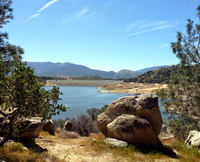
So the water in the
lake only just reaches the bottom of the dam. The dam is the grey strip running
across the centre of the photo.
Even at its reduced
level, it’s a really pretty lake. It’s still used for fishing and boating but
much less than before so the local town has gone into a decline. With lower
water levels there are more tracks around the lake and we spend a pleasant few
hours walking around part of the shoreline. This is a selection of the views. You'll be pleased to know that Jane didn't take a running jump.
We also came across
a Native American museum overlooking the lake that had many interesting local Indian
objects, but didn’t put them into any historical context or describe the tribes
customs and way of life before and after the coming of the settlers. Both
Americans and Native Americans don’t seem that comfortable with presenting
these facts; it’s something we’ve found in many places.
We also saw some original
and talented rock paintings by one of the museum staff.
Back in the
vicinity of the campsite we went for many splendid walks on those tracks that
would have led to the lake a few years ago. This is a dried-up riverbed, which I
suppose doesn’t matter so much if you’re not trying to fill the lake.
Lots of cowboy film
tumbleweed. Jane’s stopped a big rolling ball here without even using her six-gun.
Our stay could have
been a disaster, with what amounted to a false representation of the lake and
the campsite itself wasn’t well run, but we thoroughly enjoyed our stay in this
lovely area.


No comments:
Post a Comment