Monday 27 January 2014

Jan 22nd: Agrigento and the Valle dei Templi

Agrigento is the regional capital of this area of Sicily, and 30 minutes’ drive from our campsite. My guidebook tells me that the town has an interesting old quarter, but the reason for being here today is to visit the Valley of the Temples that the town overlooks. This is the town colourfully doing a bit of overlooking.


Greeks from a nearby colony founded the original town in 581 BC. They sited it on a ridge, a good defensive position. The town thrived and was enclosed by a mighty wall with nine gates.

Five main temples have been identified within the town perimeter and form the most impressive such group outside of Greece according to the experts. We entered through one of the old town gates, straight into the ruins of the temple of Castor and Pollux, the Greek Ant and Dec.


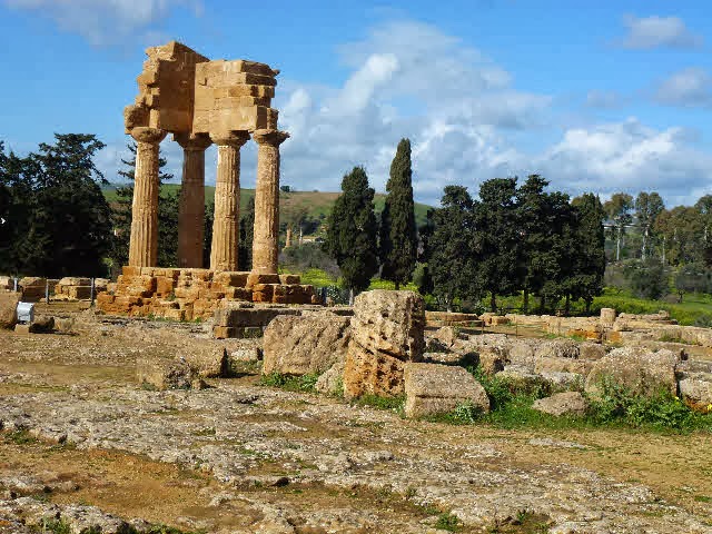
There are pieces of temple scattered everywhere, and the elegant columns in the photo were assembled in 1836 from unrelated bits, like temple Lego.

The next temple we came to was apparently the largest of this type anywhere in the Greek world: the Temple of Olympian Zeus. It was never fully completed, and what is left lies in tumbled blocks, the result of earthquakes, destructive raids and, most significantly, stone quarrying by the locals. They built the port of Empedocle nearby with Zeus’ stone in the 18th century, and there’s still plenty left.

An interesting feature is one of the main temple columns, lying on its side. The upper part of this column is an Atlas figure with his arms raised over his head simulating bearing the weight of the building. He obviously got tired and put his arms down because the temple collapsed.


From here on the temples start to look like temples. This next photo is the Temple of Juno, looking down from its elevated position. All the temples are dated from the 5th century BC so have done well to survive in any shape really.


On the site complex is a large house of more recent times. The bronze bust in the entrance is that of a tireless benefactor of the archaeological site who lived in the house from 1921 to 1933. He was Captain Alexander Hardcastle, a retired English army officer whose money came from inheriting the family bank. In 1933 the bank went bust; shortly after, poor old Capt. H entered the local lunatic asylum where he died a little later. Well, he was nuts about archaeology from his first visit here.


The Tempio della Concordia has to be one of the most beautiful ancient temples anywhere. It is remarkably intact and so perfectly proportioned that you keep taking pictures of it from every imaginable angle. They were all good when viewed on the computer later, so out of the window goes my resolve to ruthlessly prune down my huge harvest of digital snaps.

Taking photos is so much easier at this time of the year: no crowds, so you also don’t have to wait for, say, a group of schoolkids to stop swarming over the subject, or that bloke if the bright red anorak to move out of frame.


Superb, isn’t it? The next shot shows part of the line of the original city walls featuring our favourite temple in the distance.


The wall themselves were used by later occupants of the city, in the early Christian era, as burial tombs. You can see below how the stone has been hollowed out into chambers; tombites, so to speak.


A friendly French tourist offered to take our photo with a 600 year old olive tree (actually, she used my camera). Here we are with Olive and, over on the right, a recent bronze statue lying on its side looking like a giant anteater. I’m not sure why they need a modern work here when there is so much genuine antiquity to see.


The Valley of the Temples isn’t a valley at all, it’s a ridge offering fine views down to the sea and up into the hills. Most of all, the site radiated tranquillity; you almost wanted to whisper in deference to all that accumulated history.  I imagine, in its day, it was anything but quiet; full of busy people going about their daily lives. Throw in the odd earthquake and Carthaginian attack and they would maybe think our lives today the more peaceful.


Wednesday 22 January 2014

14th Jan: Camping Torre Salsa Agriturismo


The coast road from Avola to Torre Salsa is not recommended, so we took the motorway across the centre of the island and cut down to our destination at the appropriate point.

Our journey took us through broad, cultivated valleys with hills or mountains on either side. The towns and villages tended to be on the hillsides as in the photo taken when we stopped for lunch. It looks like Etna’s just exploded behind the village but it’s only a dramatic cloud.


The agriturismo bit in the blog heading simply means that the campsite’s on a farm. It is set on high ground overlooking the sea half a mile away, and is adjacent to a Natural Park. This is the view from the terrace where we checked in.


Strangely, the campsite is also a Nordic Walking Centre and obviously targets the Scandinavian sun seekers  because there are signs near each entrance to the beach stating “No Nudism”; some barely(!) readable. Maybe the Nordic Walkers then walk starkers as a protest- just watch where you’re swinging those poles!

We haven’t seen any proper Nordic Walkers and the few pitches taken are occupied by Germans, who are very friendly. So we’ve got plenty of room to spread out (we’re occupying two pitches), as you can see.


So what’s the metal structure? Are we in a hop yard, or a radar tracking station?  The iron framework is covered over during the summer months to shield motor homes and caravans from the intense sun. At those times it must feel quite claustrophobic, being full of people and vehicles and covered all over in sun-blocking material. Factor 50 material, I’m sure.

Now for some Nordic Walking: not exactly, but there are extensive tracks for the Nordic Walkers that are equally good for normal walking, and most pleasant.

Here’s a typical stretch of path, with Jane holding a bunch of wild asparagus. I’d like to claim we’d picked it ourselves, but it was given to us by a kind German couple who come here every year and know all its secrets. We were advised that wild asparagus makes a delicious omelette, and this is what Jane cooked for our evening meal. It didn’t quite live up to expectations as it was rather bitter, but we enjoyed the experience.


The various trails pass through undulating woodlands, fields and seascapes at clifftop and beach level. Here’s a sea view with a nice sunset.


Sunday 19 January 2014

Insert: Thursday Afternoon in Syracuse (Jan 9th).


Hopping back a blog to the morning when we visited the Concrete Cathedral, in the afternoon we went to the Archaeology Park across the road. To get “across the road” meant a 5 mile car journey of no-left-turns and one-way streets. But having got there the parking was ample and free, as was entry to the Arch Park.
 
The first port of call in the Park was the Greek theatre, seating 15,000, founded in the 5th century BC and rebuilt in the 3rd century BC. It is well preserved, and a sophisticated, elegant design. How advanced living standards were all those years ago for the better-off citizens!   
 
We even know some of the plays performed here, written by a playwright called Aeschylus. Ten of his plays have survived to the present day and are still performed. The surviving ten are high drama involving both mortals and the Gods, in epic settings e.g. the Persian invasion of Greece. Perhaps the ones that got lost were the comedies and the “It’s behind you!” ones. 


Climbing up behind the theatre we came upon a street with openings carved out of the rock. These are tombs, and date from the period after the Greeks and Romans. The ruts are cart tracks. Heavy stone coffins obviously.


This is the interior of one of the tombs where the niches can be seen chiselled out of the sides.


On the far side of the theatre is a large stone quarry that supplied the material for the city’s roads and major buildings. It was also used as a secure compound for prisoners of war. For example, in 415BC the city was attacked by a huge fleet of 134 ships from Athens. The offensive was defeated, and all those captured were consigned to the quarries. It looks very peaceful now with the orange trees and other bushes in the bottom.


In the quarry is an odd cave known as the Ear of Dionysius. It’s shaped like an ear and you really can hear a whisper anywhere inside the cave: apparently it magnifies sound 16 times. It’s a big ear, which is why Jane is a hardly visible dot at the entrance. But don’t  SHOUT, you’ll deafen her.


Now up the slope and round the corner to the Roman bit, a 3rd century AD amphitheatre.
Again, the amphitheatre is in good nick, and the various passageways and tunnels used by the gladiators and animals can be clearly seen, as can the audience access points to those cold stone seats.


Now here’s an odd one. A church built over the Roman baths. It’s a lovely old church, but why would you build it directly over the baths? They could have ended up baptising the whole congregation as well as the baby. But maybe the church knew a thing or two about Roman building as it’s still there in one piece today.


Last, but not least, is the tomb of Archimedes, a native of Syracuse. He was the genius of his time, an inventor, engineer, mathematician and astronomer. A famous story tells of him getting into his bath and, seeing the water level rise, suddenly realised how being immersed in water affected the weight of objects. He jumped out of the bath and ran into the street in great excitement, forgetting he was stark naked, shouting “Eureka” (meaning: “I’ve found it!”).
He was killed when the city was captured by the Romans in 215BC. It had survived a two year siege and had lasted that long largely due to Archimedes military inventions in the defence of the city.
His tomb is a carved rock doorway and the inside actually looks like a mouth with teeth. Is it meant to be Archimedes smile; or was he the inventor of dentures? Unfortunately, we’ll never know.


You think before visiting yet another archaeological site that maybe it’ll be samey- we’ve seen lots of ancient buildings recently, including really spectacular places like Pompeii. But generally each venue has its own character and this was no exception; so it was another interesting day out.


Tuesday 14 January 2014

Avola: Campsite and Town

We changed pitches after two weeks and moved to one overlooking the sea. These would be premium spots in high season but at this time of the year it’s almost deserted. We can sit in shorts between 11.00 am and 3.00 pm when the sun is shining and look over the beach to the sound of the waves.


There is direct access onto the beach where we have walked most evenings. It’s a nice sandy beach, but somewhat marred by litter, particularly at the far end which has been used as a dumping ground. They perhaps clean it up in season. In contrast, the campsite itself is immaculately tidy.


The access to the beach is through a steel gate set in the wall with the stout green railings on the mid-left of the photo so security is good, but looking directly up into the site from the beach you could think you were staying at Wormwood Scrubs-by-sea.

The headland in the distance makes a pleasant destination for the evening walk and is covered in wild irises.


The town of Avola is 2 miles from the campsite and about the size of Huntingdon. It is ambient but unspectacular in comparison with places like of Noto, and is laid out in a grid pattern of narrow streets with a fiendish one-way system. It is a true maze; it seems always to send you in the opposite direction from where you want to go, then round in circles so you lose orientation completely. Now “lost” becomes “totally lost”. Throw in for good measure erratic local driving and unpredictable pedestrians.

Avola isn’t really that sinister, it’s a regular town, as in the photo below of one of its many squares. Just go in by bus, or walk in, bike in, crawl in. But don’t drive in.


Our stay here has been very enjoyable. Tomorrow, Wednesday 15th Jan, we leave for Montallegro on the south western end of Sicily. Or simply, we’re moving 100 miles to the left.


Monday 13 January 2014

Jan 9th: Siracusa Again

Siracusa has 2700 years of history so there’s plenty to see. We’d been told that the catacombs were worth a visit. So here we are at the entrance, a lovely old ruined church. Problem: closed.


But just round the corner was another interesting building. See if you can guess what it is.


It looks like a space museum or a ship’s sail but is in fact the Cathedral of the Madonna delle Lacrime, the Madonna of the tears. It’s dedicated to a statue of the Madonna that, we are reliably informed, shed real human tears from 29th Aug to 1st Sept 1953. It seems unfair to let the antiquities in Syracuse hog the whole show, so let’s go inside and have a look at something totally modern. Here’s the lower floor.


It’s a large area featuring in the foreground what must have been the foundations of an ancient church. The brightly coloured blue-and-green “fishing umbrella” contains religious effigies when viewed from the other side. It’s a stark and sombre but powerful effect, very much in keeping with the solemn atmosphere of the ancient cathedrals.

The level above doesn’t really come over in the same way.
 

Again, it’s a vast space, now directly under the tall concrete conical spire. This floor is a cross between a Star Trek set and a multi-storey car park and it’s lost the tranquil dignity of the lower level. You just can’t win as a modern designer.
Now here’s an unusual find in the cathedral grounds


Well, yes, it’s a tree, with some quite pretty blooms that are too far away to see properly. And there are big khaki pods, also too far away to see properly, some of which are splitting with white cotton fibre spilling out. It’s a silk floss tree, related to the better known kapok tree whose fibres are also used commercially for stuffing. What you also can’t see is the spikey bark, one of just a few trees in the world with this sort of protection.

Below is a close-up. The spikes are a good two inches long and razor sharp. I shouldn’t think they get too many drunks lurching against these of an evening.


So an unscheduled but interesting morning visit. We had a less interesting pizza for lunch, and then on to the Neapolis, a large archaeological park, in the afternoon. That’s another blog.


Friday 10 January 2014

Jan 7th: Noto


In 1693 the whole of this south eastern part of Sicily was devastated by an earthquake. A few towns were rebuilt very quickly, courtesy of rich patrons who employed top architects and designers. The town of Noto is the best preserved of these and as such is a tourist showpiece. This church and convent is an example from the main street.


All the buildings in town are in the Baroque style. What’s Baroque, you ask? It’s an ornate design style much used between 1600 and 1830 in Europe, and also exported to European colonies. The internet is so useful.

The recent restorations here make some of the buildings look new, like the cathedral coming up next. The dome collapsed in 1998 so that part of it is actually new. I suppose it’s a fine point as to how much something can be restored and still claim to be essentially the original, like that excellent  brush you had that had three new heads and two new handles.


The detail is almost more impressive than the grand scale edifices. The carvings on the balcony supports all along this street are exquisitely intricate. This particular balcony is held up by five lions, all in slightly different poses. None of the lions’ faces looks very happy, especially the one nearest, on the corner.  Oh no, not dry bones again!


Presumably due to the time of year practically everything was closed, so we had a lovely wander through the town, but didn’t go inside any buildings. It’s on different levels so our walk would unexpectedly reveal a fountain or a building as in the final photo selection.


The last one was a palace that is now the Town Hall. They know how to treat their public servants round here.


Sunday 5 January 2014

Jan 2nd: Siracusa

In the UK this city is known by its ancient name of Syracuse. The oldest part is a small island just offshore, founded in 733 BC by the Greeks. Being an island it was easy to defend. It had two excellent harbours and fertile land on the mainland. With these advantages the settlement grew and prospered, and within 100 years was a thriving major city.

This is one of the harbours today, with no raiding parties in sight: the pirates are already on shore laying siege to the tourists.


A few more centuries on and Siracusa had become one of the principal Mediterranean powers. In keeping with this wealth and influence some splendid buildings were constructed, e.g. the Temple of Athena in 485 BC. Little normally survives of anything that old due to decay, earthquakes (in this part of the World), and pillaging of the building materials.
However, here is an exception: the temple of Athena was incorporated into an early Christian church, so protecting it. It is visible today as part of that structure that has itself been further modified many times. The arches are Norman, through which the temple columns are visible. It is now the Duomo (cathedral) of Siracusa, and the effect is unique.


To give an idea of how huge these temple columns are, the next photo shows a person walking at the far end of the aisle.


The cathedral is dedicated to a local saint, Santa Lucia, who is the patron saint of eyes, as her eyes were put out as part of her martyrdom.
Outside the cathedral, the square is enclosed by elegant classical style buildings, but it looks kind of bare and empty, as if it could do with a street market or a demo to bring it to life.


The island is now connected by several bridges to the modern city of Siracusa and isn’t just a museum and monuments area: there are shops, hotels and dwellings. I do like these typical Italian houses with typical lines of washing. I bet even Berlusconi hangs his smalls out to dry on the balcony of his luxury penthouse.


Now back on the tourist trail, to the Fountain of Arethusa, they say the most romantic spot on the island. It is a fresh water spring built by the Greeks and named after the nymph Arethusa who, according to legend, was transformed into this spring by the goddess Artemis. What a waste of a good nymph! Obviously she had a far-reaching reputation for purity as Nelson took on his fresh water from here before the Battle of the Nile.


After a mediocre tourist snack at the café opposite the fountain (now what else would we be expecting) we left by the 15th century Porta Marina, the ancient entrance gate from the town to the port. 15th century actually doesn’t seem that old after going back to the island’s Greek roots.


There must be few places with a continuously recorded history going back 2,700 years, so our visit was an interesting experience. Will the planet’s inhabitants be similarly entranced, in 2,700 years’ time, when the scooters in the foreground have been dredged up from the silt in the harbour and are on public display?


Wednesday 1 January 2014

29th Dec: A Walk in Cava Grande Gorge

The Cava Grande Natural Reserve starts two miles from the campsite, where the Cassibile River flows into the sea. At this point the terrain is fairly flat, but the canyon walls build as the Reserve follows the river back into the hills. It’s a good dirt track to start, with scrub vegetation on either side interspersed with orange and lemon groves. The path follows roughly the course of the river

 
It’s a great habitat for wildlife, but the birds flit past too quickly to photograph, so you’ll have to make do with a large green lizard and an unidentified butterfly.


As the hills start to rise on either side, we notice lots of doors and windows cut into rocks far up on the slopes on the opposite side of the river. Later the internet  reveals these to be cave dwellings which were occupied from BC times up to the last century. The info’s pretty vague so I don’t know any more than that. You’ll have to supply your own Flintstones images for life way back when in Cavagrande Rock Village.


We pass olive trees, as well as the oranges and lemons, and one of these presents a most unusual gnarled shape of three trunks growing out of the one base. It’s obviously very old and worth a photo.


Moving on up the valley we come across an abandoned mill outside which we ate our packed lunch. The interior looks like it could spring back into life straight away if you knew how to operate it and knew what you were supposed to be milling. The valley has only the olives, oranges and lemons so maybe it’s a marmalade mill.


 The dirt track merges with a partly tarmacked road leading to a disused hydroelectric generating complex; thereafter it peters out into a barely traceable hillside path. We follow the path for a while to get a view of the steepening valley, as the photo shows, with one of the derelict hydroelec buildings on the valley floor.
The cliffs here are about 1,500 feet high and carry on for a further 5 miles. This further on part is reached from a different access point that involves descending 800 feet to the river before starting to explore, and then 800 feet back up at the end.  We’ll stick with this side, thanks.


It’s easy to dismiss more modern structures in favour of ancient buildings. On our return, I was struck by how harmoniously this railway bridge fitted in to the Reserve, with its elegant arches spanning the river. We also went under the recent motorway bridge on the way back, a real slab which I won’t be reproducing!


The Reserve was unobtrusively managed, so no obvious signs of intervention: in fact no signs at all, so you didn’t get any info as you went round or on which paths to take. But all part of the charm and, really, a smashing day out.