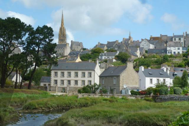
Friday 30 June 2017

Brittany: Scenic Panoramas

Brittany is as far west as France goes, and we are staying nearest one of the most westerly points. The sun sets at 10:20 pm at this time of year so there’s some twilight left even for us late birds at bedtime.

Two headlands together mark the western extremity and we chose the one called the Pointe Du Van to check out. It’s wild and rugged with a huge views all around.
You might notice a building on top of the cliff. It’s a chapel dedicated to St. They, an obscure local saint. We walked over for a closer look and found a well maintained but locked chapel perched on the cliff edge. The figure on top of the statue pole is of St. They, so they say.
There were miles of paths on the level clifftop area with shrubs and plants attracting birds like stonechat and skylarks.
There must have been more people living on this flat, empty expanse in past time as there were two ornate wells, one of which Jane is stood next to. We spotted this from a distance when it looked like a large dog kennel within which might have lurked a fearsome beast ready to rush out and see you off.
In the hazy distance the island of Sein can be seen. It has a population of about 500 and the traditional occupation is fishing. It is only half a square mile in area and low lying, and was totally covered by the sea in 1868 and 1896. The possibility of global warming and melting icecaps is a real worry here. 

In June 1940, when General de Gaulle appealed for volunteers to join the Free French Forces, the entire 130 strong adult male population sailed for England to answer the call. De Gaulle came personally in 1946 to award the island the Liberation Cross.
Our next viewpoint: a mountain, Menez-Hom. A mountain in Breton terms, that is, just over 1,000 ft high, but with a 360 degree panorama. It was a blisteringly hot day when we went, with the idea that it would be cooler on a mountain top. Perversely, it worked the other way round. The car showed 27 degrees at the bottom, and 30 degrees at the top.
The car park near the top led onto a network of paths, but walking in that  temperature didn’t appeal. We simply plodded up to the top, where a survey point stood, and viewed the panorama. It was extensive, but hazy because of the hot weather.
Just one photo then, from the survey point, that hopefully gives an indication of the view that probably best emerges on a cold, clear winter’s day. Then we’d be complaining about the cold!
At the bottom of the mountain we stopped in the village of the same name to admire the church of Ste-Marie-de-Menez-Hom, but first noticed a monument in the car park. It commemorated the French Resistance seizing Menez-Hom from the Germans in 1944 after a bitter fight. We noticed some concrete ruins when we were on the mountain so these must have been the German defences that were attacked and captured by the Resistance.
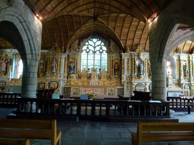
The church itself was magnificent, dating from 1739, with a typically Breton ornate bell tower.
 The detail on the calvary crosses is very fine but not possible to exactly interpret.
The altarpiece of guilded, carved biblical figures covered the whole of the eastern wall. These were of fine quality and unexpectedly extensive for a small rural church.
It’s strange how things turn out. It was too hot and hazy for us to get much out of Menez-Hom the mountain, but Menez-Hom the village church was a delight. That’s the unpredictable delight of travelling.


Wednesday 28 June 2017

Thursday 24th June: Locronan

Locronan is a tourist town, a time warp from the 17th and 18th centuries, when fine buildings were erected with wealth derived from sailmaking. Locronan sails were sold to French, Spanish and English navies, even though the Royal Navy was often at war with France. Business is business.

Sailmaking started here in the 15th century and grew into a rich industry several centuries later that gave us the town we see today. This is part of the main square.
The town has some Roman roots but it’s generally allowed that it was founded in the 7th century by Bishop Ronan from Ireland. “Loc” means “place” in the Breton language so Locronan means “Ronan’s Place”. St. Ronan introduced Christianity to the area that was Druidic before he arrived and his miracles gave Locronan its first prosperity as people flocked here as to pay homage. The miracles must still be working as they’re still flocking in.
The solid main church is dedicated to St. Ronan and fits in nicely with the look of the main square where it is located.
The whole place looks similar, being of the same period and built of  granite. That’s its charm and also its drawback because the photos look similar, but we’ll run through a couple more. First the Town Hall.
Now the creperie where Jane and I enjoyed a crepe & coffee before we left.
And a side-street.
There were a lot of niches in the dwellings for saints and other religious icons. This one houses Mary and Jesus under a heart-shaped top stone
The atmospheric Notre Dame de Bonne Nouvelle chapel dates from 1439. That means “Our Lady of Good News” chapel. The good news may be that the chapel is still standing.
The town has been used many times as a film location, for instance Roman Polanski’s Tess that won various achademy awards.
Locronan is touristy, with the expected tourist shops, but these were of good quality if somewhat expensive. It was all well run and we certainly had a good day out.


Sunday 25 June 2017

Walk to the Mill, & the Rescue

We decide to walk along the cliff path to the restored mill, a different direction from the way we went previously. Looking down on the spectacular jagged rocks and steep-sided coves made us realise that it wouldn’t do to slip off the path. 
En route, we pass a rock housing a cormorant colony where they are feeding young. You’ll have to take my word for it as the birds look tiny on the photo, but we could see them clearly through binoculars.
Before turning inland to the mill, we arrive at Miller’s Point.The house on the Point, in the photo below, is run by the lighthouse and coastguard authority according to the sign on the gate. It has a great perspective along the coast, but no evidence of a light or coastguards, so maybe it’s a home for retired lighthouse keepers.
Now we’re at the restored mill. It’s set in an idyllic green valley with the wheel slowly revolving. The wheel is large and slender, more like one of a set of gigantic wheels on an ancient machine that plods its way through the undergrowth belching smoke and steam.
Inside it’s been nicely restored with cogs going round operating a millstone, as restored mills do, but this one had an unusual feature- the miller’s bed, with what looks like a guest appearance of the miller’s ghost.
We returned via easier inland tracks to the campsite. Our thoughts about the dangers of the rocks and coves became fact a few days later. Sat outside the caravan, we heard emergency vehicles heading for the beach; minutes later a helicopter sped over. We then saw it hovering somewhere to the right of the beach over the rocks.
We walked down to the beach to see what was happening. Clearly a rescue was in progress.
The helicopter circled many times around the the beach and into an adjacent cove that was cut off by the sea. The winchman went down, and each time a survivor was brought out. It was flying of the greatest precision as the blades were close to the cliff.
 We learned later that the oldest member of a family diving party, a 54 year old man, had been taken ill in the cove. The younger members had signalled for help and then tried to revive him. They were all now trapped in the cove. The eight youngsters were all airlifted out with minor injuries but the paramedics couldn’t revive the older guy. So not a totally happy ending, but certainly not for any lack of speed in response or professionalism by the rescue services in attending the incident.


Thursday 22 June 2017

Sunday 18th June: The Fastnet Race

This is a big race in the calendar, although you wouldn’t guess so from the makeshift banner on the quay strung between two rubbish skips,
It’s an ocean race around the Fastnet lighthouse at the tip of Southern Ireland. I thought originally that the  description “Mini” meant that the  race would be around a tiny Fastnet lighthouse, as opposed to the full size one. However, it refers to the restriction on the length of the competitors sailboats: no more than 6.5 metres; that’s apparently small by ocean racing standards. There are 56 craft with two crew to each.
This is the forest of masts the day before the race.
This is what 6.5 metre yachts look like close up.There’s a crew member on board the middle one for scale. No restriction on width, though, so my competition yacht would need to be 6.5 metres long by 15 metres wide. 
There is frantic activity. Items being stowed, sails being checked and running repairs. This guy’s in a frogman suit fixing the rudder. Can’t have the boat going round in circles.
Another boat is on it’s side for repair- but still in the water! The craft look like small lifeboats, so I guess there’s no danger of them sinking.
We’re down at the pleasure port, Treboul, the next day, to see the start of the race. There’s hardly any wind in the port so each boat is towed out to the starting point a mile or so off shore. Here they go past the harbour entrance.
Meantime, we’ve found a little bay round the corner from the breakwater where we can eat our picnic and watch the competitors emerging under tow into the open sea.
 It takes a couple of hours to tow out all 56 boats, so we have plenty of time to eat and get up to our viewpoint on the top of the cliff to watch the 3:00 pm start. They stream out steadily and mill around over a wide area in the bay. Some other yachts sail out too, for instance this handsome older vessel with the brown sails. You can see the race competitors in the background.
A schooner on the far side carries the race officials and the starter. It’s getting towards 3:00 pm and you wonder how they’ll manage to assemble the participants into some sort of starting line; they are all over the place. Miraculously, as it approaches 3:00, they all seem to bunch together, as this long distance shot shows. That’s seamanship!
In most races, when the gun goes off, the competitors zoom away from the start line and jostle for position. In sailing, the gun (hooter, actually) goes off- and nothing happens. Then, ever so gradually and gracefully, the yachts form a line and head for the open sea in a most orderly fashion.
I’m sure it can’t be this gentlemanly all the way, and there has to be a drive to win as in all top level sports. Presumably, they’re monitored by satellite so that one doesn’t cut a corner by not rounding the lighthouse, or another rendezvous with a pal who gives a tow in his high powered speedboat.
But seriously, these are highly professional sailors, and whereas today the sea is a millpond, it can quickly change into a raging storm which they will need to sail through. I’ll stick to a punt on the river Cam, thanks.


Tuesday 20 June 2017

Brittany: Some Local Towns

The first impression is of solidly built houses with slate roofs, able to cope with any weather. This photo of Pont-Croix, the small town nearest the campsite, is typical.
It might look rather dour and somewhat English, compared to the vibrant colours of the Mediterranean, but there is plenty of charm and interest here. Take for instance this intricate 14th century porch on the main church.
There is also a tide mill in the estuary, not in working order, but well preserved none the less. You can see the water entry points at the bottom of the building. The estuary looks like it could do with a good clean out for the mill to be working efficiently.
The old town centre is at the top of the hill around the church where there are cobbled streets and old buildings. In this picture we are looking towards a 17th century Ursuline convent church that is oddly marked on my tourist information brochure as the “ancient clothes drying shed”! This shed was clearly of some historical importance-  perhaps the equivalent of the school bike sheds, tucked round the back, where the nuns went for a quiet ciggy.
On to Douarnenez, a larger town and an important fishing port, even today. It could be described as “shabby chic” as demonstrated by the peeling paintwork on this row of (originally) smart buildings overlooking the pleasure port.

This is the pleasure port that the buildings face. The white buildings on the left in the photo are part of the modern fishing port complex, landing mackerel, sardines, tuna and lobster. The town also produces the greatest amount of canned fish in Europe.
 Along the prom is a building housing a fishing magazine. It was built in 1914 as a seaman’s mission to look after those who had fallen on hard times or difficulties It was founded by a wealthy  American who was moved by the plight of the unemployed fishermen when he visited the area before the First Word War.
You pass many individual cottages around the town, like this pair, the one on the right looking at you with astonished top window eyes.
It has to be said, they do make an effort with flowers in all the towns and villages. This restaurant is a bit OTT, but quite striking. Don’t think there’s a risk of anyone nicking the bike.
It’s an area that we have warmed to- “warm” being the operative word as it’s been over 30 degrees these last few days. That’s not typical for Brittany; it’s usually like west coast UK but slightly warmer.


Saturday 17 June 2017

June 8th: to Brittany

A full day’s drive takes us to Pors Peron in Brittany. Pors Peron is a hamlet with a campsite of the same name. This is where we are staying. It’s 300 metres down a steep road to the beach, a pretty cove with fine sand.
It’s a rugged coastline very much like Cornwall; in fact, this area is called La Cornouaille. There is a splendid path following the whole coast along the clifftops from where walkers can get great views. Even on a fairly calm day there is some surf, especially around the exposed rocks.
The path itself is well maintained and mostly quite manageable but there are some scrambles that come close to the cliff edge and even closer to threatening one’s comfort zone. The photo below is of an easy bit.
Passing through one of the many small bays joined by the coast path, we noticed this monument. It commemorates the 23/24th August 1943 when a crew of 8, with 14 passengers, set sail for England to join the Free French forces. There are many other such  instances from all along the coast according to the guide book; it doesn’t say if any sailed back again in disillusion.
 We return to the campsite via an inland route, passing this farm building on the way. Notice anything unusual? A brand new roof with a huge dent in it: could the cows be trampolining nearby?
This is home for the time being, a large, quiet, level pitch. The climate here is mild due to the proximity of the sea, which accounts for the palm tree. The site is owned and run by Brits with a high proportion of Brit campers. It’s very ship-shape with a swimming pool and full facilities- but, disappointingly, no cricket pitch.